1970s Maps of Northwest Hills Planning Region, Connecticut
Explore 8 historic maps of Northwest Hills Planning Region from the 1970s. These maps offer a rare glimpse into what life looked like during the 1970s — showing old roads, neighborhoods, homes, and landmarks that have changed or disappeared over time.
Whether you're researching your family's past, planning a metal detecting trip, or studying how Northwest Hills Planning Region's landscape evolved across the 1970s, these high-resolution maps are a powerful tool for exploring the history of this region.
- Focus on a specific era: All maps on this page are from the 1970s, giving you a focused view of this time period.
- See what’s changed: Compare century-old streets, trails, and buildings to today's modern landscape using overlays and satellite layers.
- Research with precision: Use these maps for genealogy, historical research, land use analysis, or educational projects.
- View, download, or print: Maps are fully viewable online in high resolution, and can be downloaded or printed for your own records.
Start exploring Northwest Hills Planning Region's history through authentic maps from the 1970s. This is your window into the past.
Northwest Hills Planning Region, CT maps
(8)- 1971 Map of West Granville, 1973 Print
 1971 West Granville1973 Print · USGSThe Massachusetts and Connecticut borderlands are captured here in the early 1970s, featuring the expansive waters of the Farmington River Reservoir. Local historians can trace old mountain roads and sites like West Granville, Woodland Cem, and Baird Four Corners.6 unique versions available
 - 1972 Map of Southwick, 1974 Print
 1972 Southwick1974 Print · USGSThe borderlands of Southwick and Granville are captured here in the early 1970s, showcasing a landscape of glacial lakes and steep mountain ridges. You can trace the historic lakefront at Congamond Lakes, find local schools like Powder Mill Sch, and locate old burial grounds including Northeast Cem.4 unique versions available
 - 1975 Map of Ashley Falls, 1981 Print
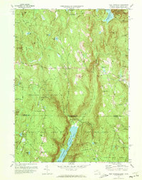
 1975 Ashley Falls1981 Print · USGSThe Berkshire valley on the Connecticut border is shown in the mid-1970s, revealing the intricate meanders of the Housatonic River. Trace the rural road networks and field patterns connecting Ashley Falls, Sheffield, and Clayton.
 - 1975 Map of Tolland Center, 1981 Print
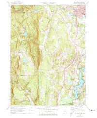
 1975 Tolland Center1981 Print · USGSThe Massachusetts-Connecticut borderlands appear in sharp detail during the mid-1970s, focused on the river valleys of the Berkshire highlands. Local historians can trace old road alignments and property boundaries near Tolland Center, New Boston, and the waters of Colebrook River Lake.
 - 1975 Map of Bashbish Falls, 1981 Print
 1975 Bashbish Falls1981 Print · USGSThe tri-state border region comes into focus in the mid-1970s through this aerial orthophotograph of the Berkshires. Researchers can trace the layout of small communities like Joyceville and Taconic against the heights of Mt Everett and Bear Mtn.
 - 1975 Map of South Sandisfield, 1981 Print
 1975 South Sandisfield1981 Print · USGSThe southern Berkshire highlands appear in high detail during the mid-seventies in this photographic survey of the Massachusetts-Connecticut border. Trace the rural crossroads of Southfield and Montville or follow the course of the Blackberry River.
 - 1975 Map of West Granville, 1981 Print
 1975 West Granville1981 Print · USGSThe Massachusetts and Connecticut borderlands appear in sharp detail in the mid-1970s, before modern development further altered the rural landscape. Researchers can trace historic crossroads at Baird Four Corners and examine the massive footprints of Cobble Mountain Reservoir and West Granville.
 - 1976 Map of Southwick, 1981 Print
 1976 Southwick1981 Print · USGSThe Massachusetts-Connecticut borderlands are captured in detail during the mid-seventies, showing the agricultural and residential patterns of the day. Genealogists and local historians can trace family properties and land use near Southwick, Gillett Corner, and the Congamond Lakes.
End of results
Showing maps 1-8 of 8
Top cities of Northwest Hills Planning Region
- Torrington historical maps
- Burlington historical maps
- Litchfield historical maps
- New Hartford historical maps
- Harwinton historical maps
- Salisbury historical maps
See more
Frequently asked questions
- What are the different types of historical maps available for Northwest Hills Planning Region?
- What is the oldest map of Northwest Hills Planning Region?
- Where can I purchase historical maps of Northwest Hills Planning Region for my home or office?
- Where can I download high-res historical maps of Northwest Hills Planning Region?
- Are there historical topographic maps available for Northwest Hills Planning Region?
- Is there historical aerial imagery available for Northwest Hills Planning Region?
- Where are historical maps of Northwest Hills Planning Region sourced from?