1940s Maps of Torrington, Connecticut
Explore 4 historic maps of Torrington from the 1940s. These maps offer a rare glimpse into what life looked like during the 1940s — showing old roads, neighborhoods, homes, and landmarks that have changed or disappeared over time.
Whether you're researching your family's past, planning a metal detecting trip, or studying how Torrington's landscape evolved across the 1940s, these high-resolution maps are a powerful tool for exploring the history of this region.
- Focus on a specific era: All maps on this page are from the 1940s, giving you a focused view of this time period.
- See what’s changed: Compare century-old streets, trails, and buildings to today's modern landscape using overlays and satellite layers.
- Research with precision: Use these maps for genealogy, historical research, land use analysis, or educational projects.
- View, download, or print: Maps are fully viewable online in high resolution, and can be downloaded or printed for your own records.
Start exploring Torrington's history through authentic maps from the 1940s. This is your window into the past.
Torrington, CT maps
(4)- 1947 Map of Hartford, 1955 Print
 1947 Hartford1955 Print · USGSSouthern New England and the Hudson Valley are shown in detail during the post-war expansion era. Genealogists and researchers can trace local landmarks from the State Capitol and Yale University to the Stratford Lighthouse and Woodlawn Cem.2 unique versions available
 - 1948 Map of Hartford
 1948 Hartford1948 Print · USGSSouthern New England is captured here in the late 1940s, showcasing a landscape of thriving industrial cities and developing parkways. Genealogists and historians can trace the rail networks of the New York New Haven and Hartford RR or locate coastal defense sites like Fort Terry and Camp Shanks.2 unique versions available
 - 1948 Map of Torrington, 1955 Print
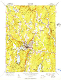
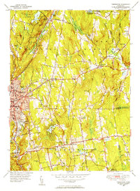 1948 Torrington1955 Print · USGSLitchfield County's industrial and rural heart comes alive in this post-war survey of Torrington and its surrounding hill towns. Genealogists and historians can trace family locations near Hillside Cemetery, the Torringford Ch, and the outlying settlement of Bakersville.
 - 1948 Map of Winsted, 1956 Print
 1948 Winsted1956 Print · USGSMid-century Winsted and the surrounding hill towns are captured here at a peak of rail and river-based industry. Genealogists can locate family sites at St Joseph Cem, trace the grounds of The Little Red Schoolhouse, or explore the many summer camps like Camp Wahanda.
End of results
Showing maps 1-4 of 4
Top cities near Torrington
- Waterbury historical maps
- Bristol historical maps
- Southington historical maps
- Farmington historical maps
- Watertown historical maps
- Avon historical maps
See more
Top neighborhoods of Torrington
- Burrville historical maps
- Torringford historical maps
- Drakeville historical maps
- West Torrington historical maps
- Wrightville historical maps
- Newberry Corner historical maps
See more
Frequently asked questions
- What are the different types of historical maps available for Torrington?
- What is the oldest map of Torrington?
- Where can I purchase historical maps of Torrington for my home or office?
- Where can I download high-res historical maps of Torrington?
- Are there historical topographic maps available for Torrington?
- Is there historical aerial imagery available for Torrington?
- Where are historical maps of Torrington sourced from?