1950s Maps of Meriden, Connecticut
Explore 4 historic maps of Meriden from the 1950s. These maps offer a rare glimpse into what life looked like during the 1950s — showing old roads, neighborhoods, homes, and landmarks that have changed or disappeared over time.
Whether you're researching your family's past, planning a metal detecting trip, or studying how Meriden's landscape evolved across the 1950s, these high-resolution maps are a powerful tool for exploring the history of this region.
- Focus on a specific era: All maps on this page are from the 1950s, giving you a focused view of this time period.
- See what’s changed: Compare century-old streets, trails, and buildings to today's modern landscape using overlays and satellite layers.
- Research with precision: Use these maps for genealogy, historical research, land use analysis, or educational projects.
- View, download, or print: Maps are fully viewable online in high resolution, and can be downloaded or printed for your own records.
Start exploring Meriden's history through authentic maps from the 1950s. This is your window into the past.
Meriden, CT maps
(4)- 1952 Map of Middletown, 1954 Print
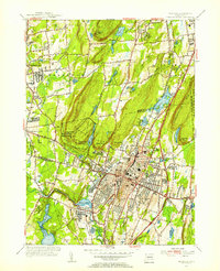
 1952 Middletown1954 Print · USGSThe Connecticut River valley thrives in the early fifties as Middletown and Portland expand around their industrial and academic roots. Genealogists and historians can locate Indian Hill Cemetery, the Swedish Orphanage, and the old Brazos Quarry.3 unique versions available
 - 1953 Map of Durham, 1954 Print
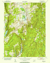 1953 Durham1954 Print · USGSThe rural heart of Middlesex County is captured in the early fifties, showing a landscape of small crossroads villages and steep ridges. Genealogists and hikers can trace old routes like Stagecoach Road, locate the Bluff Head Cemetery, and explore the rail corridor through Reed Gap.4 unique versions available
 - 1954 Map of Wallingford, 1956 Print
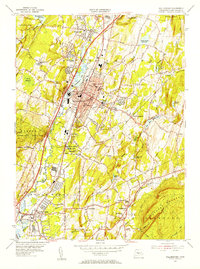 1954 Wallingford1956 Print · USGSThe Quinnipiac River valley in the mid-1950s shows the bustling center of Wallingford alongside its growing suburban neighborhoods. Trace local family roots at St Johns Cem or locate historic landmarks like the Gaylord Farms Sanatorium and Lyman Hall High Sch.3 unique versions available
 - 1955 Map of Meriden, 1956 Print
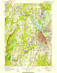
 1955 Meriden1956 Print · USGSMid-century Meriden and Southington are shown here during a period of significant post-war development and infrastructure growth. Genealogists can trace family landmarks at Bishops Corner and Stillmans Corner, or locate ancestors at Walnut Grove Cem.3 unique versions available
End of results
Showing maps 1-4 of 4
Top cities near Meriden
- Hartford historical maps
- New Haven historical maps
- Waterbury historical maps
- New Britain historical maps
- West Hartford historical maps
- Bristol historical maps
See more
Top neighborhoods of Meriden
Frequently asked questions
- What are the different types of historical maps available for Meriden?
- What is the oldest map of Meriden?
- Where can I purchase historical maps of Meriden for my home or office?
- Where can I download high-res historical maps of Meriden?
- Are there historical topographic maps available for Meriden?
- Is there historical aerial imagery available for Meriden?
- Where are historical maps of Meriden sourced from?