1980s Maps of North Stonington, Connecticut
Explore 5 historic maps of North Stonington from the 1980s. These maps offer a rare glimpse into what life looked like during the 1980s — showing old roads, neighborhoods, homes, and landmarks that have changed or disappeared over time.
Whether you're researching your family's past, planning a metal detecting trip, or studying how North Stonington's landscape evolved across the 1980s, these high-resolution maps are a powerful tool for exploring the history of this region.
- Focus on a specific era: All maps on this page are from the 1980s, giving you a focused view of this time period.
- See what’s changed: Compare century-old streets, trails, and buildings to today's modern landscape using overlays and satellite layers.
- Research with precision: Use these maps for genealogy, historical research, land use analysis, or educational projects.
- View, download, or print: Maps are fully viewable online in high resolution, and can be downloaded or printed for your own records.
Start exploring North Stonington's history through authentic maps from the 1980s. This is your window into the past.
North Stonington, CT maps
(5)- 1983 Map of Old Mystic, 1984 Print
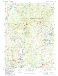 1983 Old Mystic1984 Print · USGSIn the early eighties, the borderlands of Ledyard and Stonington preserved a balance of tribal lands and small New England villages. Researchers can trace family history through the Mashantucket Burial Ground, locate the old Wheeler High Sch, and follow the winding Shunock River.3 unique versions available
 - 1984 Map of Block Island
 1984 Block Island1984 Print · USGSThe coastal borderlands of Rhode Island, Connecticut, and New York are captured here in the mid-eighties, from the rail hubs of Westerly to the shores of Block Island. Genealogists and historians can trace the shoreline's evolution through landmarks like the Pequot Indian Res, New Shoreham, and Narragansett Pier.
 - 1984 Map of Jewett City
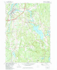 1984 Jewett City1984 Print · USGSJewett City and the surrounding Griswold hills appear in the mid-1980s as a landscape defined by its river-driven industry and deep woods. Researchers can trace family sites at Geer Cem or locate old crossings near Doaneville and the Pachaug Pond shoreline.3 unique versions available
 - 1984 Map of Providence, 1985 Print
 1984 Providence1985 Print · USGSThe Rhode Island coast and its industrial heartlands are captured here in the mid-eighties, showing the density of the Providence metro area. Researchers can trace historic rail lines like the Providence & Worcester RR and explore the maritime layout of Narragansett Bay and Newport.
 - 1984 Map of Ashaway, 1985 Print
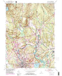 1984 Ashaway1985 Print · USGSThe Rhode Island and Connecticut border comes alive in the mid-eighties as a landscape of river-driven industry and forest management. Genealogists and historians can trace the development of riverside villages like Potter Hill and White Rock or follow the path of the Conrail line.2 unique versions available
End of results
Showing maps 1-5 of 5
Top cities near North Stonington
- Norwich historical maps
- Groton historical maps
- Coventry historical maps
- New London historical maps
- Southold historical maps
- Montville historical maps
See more
Top neighborhoods of North Stonington
- Laurel Glen historical maps
- Clarks Falls historical maps
- North Stonington Village Historic District historical maps
Frequently asked questions
- What are the different types of historical maps available for North Stonington?
- What is the oldest map of North Stonington?
- Where can I purchase historical maps of North Stonington for my home or office?
- Where can I download high-res historical maps of North Stonington?
- Are there historical topographic maps available for North Stonington?
- Is there historical aerial imagery available for North Stonington?
- Where are historical maps of North Stonington sourced from?