Old Maps of North Stonington, Connecticut for Metal Detecting
Plan your next treasure hunt with 48 historic maps of North Stonington. Find old homesites, ghost towns, trails, and gathering spots that may be lost to time — perfect for identifying promising metal detecting locations.
- Locate forgotten sites: Uncover places like long-lost settlements, abandoned rail lines, or gathering spots.
- Plan better hunts: Use map overlays combined with LiDAR or satellite views to narrow in on historically rich areas.
- Made for detectorists: Thousands of hobbyists use these maps to discover relics, coins, and hidden history.
Use these historic maps to boost your research and find new opportunities beneath the surface of North Stonington.
North Stonington, CT maps
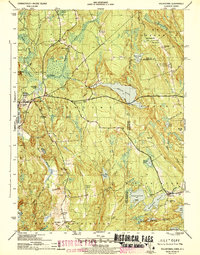
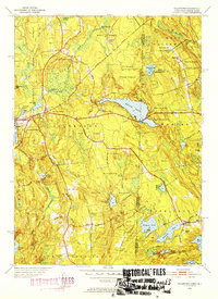
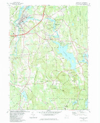
(48)- 1889 Map of Stonington
 1889 Stonington1889 Print · USGSThe Connecticut and Rhode Island borderlands are documented here at the height of the maritime and rail era. Genealogists and historians can trace family-named hills like Stewart Hill or locate industrial sites such as the Silax Mine and the rail hub at Mystic Bridge.
 - 1889 Map of Moosup
 1889 Moosup1889 Print · USGSThe Connecticut-Rhode Island borderlands were a hive of rail activity and river power in the late nineteenth century. You can trace early transit routes through Plainfield Junction or locate rural landmarks like Moosup Valley P.O. and Sterling Station.
 - 1893 Map of Moosup
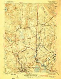
 1893 Moosup1893 Print · USGSEastern Connecticut and western Rhode Island meet here in the late nineteenth century at a peak of rail-driven industry. Genealogists can trace family footprints through historic hubs like Jewett City, Hopkins Hollow, and the mills surrounding Pachaug Pond.7 unique versions available
 - 1893 Map of Stonington
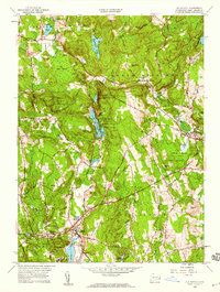
 1893 Stonington1893 Print · USGSThe coastal borderlands of Connecticut and Rhode Island are captured here in the late nineteenth century, showing a landscape defined by maritime trade and river power. Genealogists can trace family landmarks like Ayer Hill and Pequot Hill or locate industrial sites such as the Silex Mine.10 unique versions available
 - 1920 Map of Moosup
 1920 Moosup1920 Print · USGSEastern Connecticut and the Rhode Island border were thriving hubs of textile milling and rail transit just after the Great War. Genealogists and local historians can trace family-named locations such as Hopkins Hollow, industrial sites like Sterling Station, and the intricate rail network at Plainfield Junction.
 - 1921 Map of Stonington
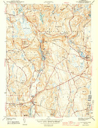
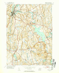
 1921 Stonington1921 Print · USGSCoastal Connecticut and Rhode Island meet here between the wars, where river and rail drive the regional economy. Genealogists can trace family footprints in North Stonington and Westerly, or locate the Silex Mine and the Light House at Stonington.
 - 1942 Map of Block Island, 1943 Print
 1942 Block Island1943 Print · USGSThe coastal borderlands of Rhode Island and Connecticut are captured here during the wartime years, documenting a landscape defined by rail and sea. Researchers can trace the NY NH & H RR through historic mill villages or locate landmarks like the Silex Mine and Indian Burying Hill.2 unique versions available
 - 1943 Map of Voluntown
 1943 Voluntown1943 Print · USGSThe Connecticut and Rhode Island borderlands are shown here during the early 1940s, capturing the rural character of New London and Washington Counties. Researchers can trace ancestral locations at Rockville and Voluntown, or locate historic sites like Wylie Sch and the Rockville Cem.4 unique versions available
 - 1943 Map of Ashaway
 1943 Ashaway1943 Print · USGSThe Rhode Island-Connecticut borderlands during the early 1940s are defined here by textile-mill settlements and old turnpikes. Genealogists can trace family names and sites from Stillmanville to Potter Hill, including landmarks like Oak Grove Cem and St Michael Cem.2 unique versions available
 - 1943 Map of Old Mystic
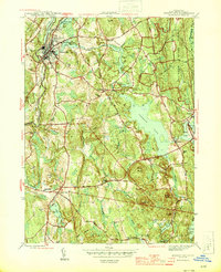
 1943 Old Mystic1943 Print · USGSCoastal Connecticut’s rural interior is captured here during the early war years, showing the intersection of Ledyard, Groton, and North Stonington. Genealogists can locate family landmarks such as Haleys, Burnetts Corner, and the Pequot Indian Reservation.2 unique versions available
 - 1943 Map of Putnam, 1944 Print
 1943 Putnam1944 Print · USGSThe Connecticut and Rhode Island borderlands are captured here during the wartime era, showing a landscape defined by textile river towns and sprawling state forests. Trace the industrial rail corridor of the New York New Haven and Hartford through Putnam, Danielson, and Moosup.
 - 1944 Map of Jewett City
 1944 Jewett City1944 Print · USGSGriswold and Voluntown appear during the mid-forties as a landscape of mill ponds, family-named hills, and developing state forest land. Researchers can trace the industrial corridor of the Hartford New Haven and New York RR or locate rural landmarks like Bethel Ch and Pachaug Cem.3 unique versions available
 - 1947 Map of Providence, 1948 Print
 1947 Providence1948 Print · USGSSouthern New England is captured in the mid-1940s, showing a landscape defined by busy industrial ports and expanding military installations. Researchers can trace the rail lines of the N.Y. N.H. & H. RR or locate coastal defenses like Fort Adams and Quonset Point.5 unique versions available
 - 1948 Map of Providence, 1951 Print
 1948 Providence1951 Print · USGSSouthern New England’s coastal reaches are captured here in the late 1940s, from the industrial heart of Providence to the tip of Provincetown. Genealogists and historians can trace rail lines like the Central Vermont Railway and locate active military sites such as Otis Air Force Base and Fort Rodman.
 - 1953 Map of Voluntown, 1954 Print
 1953 Voluntown1954 Print · USGSThe Connecticut and Rhode Island borderlands come alive in the 1950s, showing a landscape defined by timber, state forests, and glacial ponds. Researchers can trace family names and landmarks from Voluntown to Rockville, or find sites like Sawmill Pond and Stepstone Falls.5 unique versions available
 - 1953 Map of Jewett City, 1955 Print
 1953 Jewett City1955 Print · USGSJewett City and the surrounding Quinebaug valley are captured here in the mid-fifties, showing a landscape of river-driven industry and growing state forests. Researchers can trace old schoolhouse locations like Preston Sch and Glasgo Sch or explore family-named sites such as Taylor Hill and Rix Town.5 unique versions available
 - 1953 Map of Ashaway, 1955 Print
 1953 Ashaway1955 Print · USGSThe borderlands of Connecticut and Rhode Island are captured here in the mid-1950s, centered on the river-powered mill towns of the Pawcatuck Valley. Researchers can trace historic industrial sites and neighborhood roots in Westerly, Ashaway, and the riverside hamlet of Potter Hill.5 unique versions available
 - 1957 Map of Providence
 1957 Providence1957 Print · USGSCoastal New England at the height of the mid-century era shows a landscape shaped by maritime industry and Cold War defense. Genealogists and historians can trace the reach of the New York, New Haven & Hartford RR and locate legacy sites like Fort Adams and Quonset Point Naval Air Station.
 - 1958 Map of Providence
 1958 Providence1958 Print · USGSThe Rhode Island and Massachusetts coastlines are shown in detail during the late 1950s, from the urban cores to the tips of the islands. Researchers can trace the mid-century footprint of Quonset Point Naval Air Station, the defense works at Fort Adams, and the rail network of the New York, New Haven and Hartford RR.
 - 1958 Map of Old Mystic, 1959 Print
 1958 Old Mystic1959 Print · USGSCoastal Connecticut woodland and small hamlets are preserved in this mid-century survey of the Mystic River headwaters. Genealogists can trace family landmarks and schools including Burnetts Corner, Shewville, and the Wheeler High Sch.2 unique versions available
 - 1963 Map of Providence
 1963 Providence1963 Print · USGSSouthern New England's coastal and industrial heartland is captured here in the early sixties, from the Rhode Island mainland to the far reaches of the Cape. Researchers can trace mid-century growth in Providence or locate landmarks on Marthas Vineyard and Nantucket Island.
 - 1983 Map of Old Mystic, 1984 Print
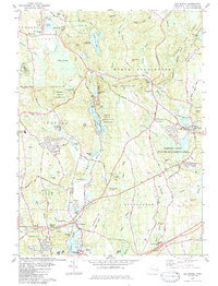 1983 Old Mystic1984 Print · USGSIn the early eighties, the borderlands of Ledyard and Stonington preserved a balance of tribal lands and small New England villages. Researchers can trace family history through the Mashantucket Burial Ground, locate the old Wheeler High Sch, and follow the winding Shunock River.3 unique versions available
 - 1984 Map of Block Island
 1984 Block Island1984 Print · USGSThe coastal borderlands of Rhode Island, Connecticut, and New York are captured here in the mid-eighties, from the rail hubs of Westerly to the shores of Block Island. Genealogists and historians can trace the shoreline's evolution through landmarks like the Pequot Indian Res, New Shoreham, and Narragansett Pier.
 - 1984 Map of Jewett City
 1984 Jewett City1984 Print · USGSJewett City and the surrounding Griswold hills appear in the mid-1980s as a landscape defined by its river-driven industry and deep woods. Researchers can trace family sites at Geer Cem or locate old crossings near Doaneville and the Pachaug Pond shoreline.3 unique versions available
 - 1984 Map of Providence, 1985 Print
 1984 Providence1985 Print · USGSThe Rhode Island coast and its industrial heartlands are captured here in the mid-eighties, showing the density of the Providence metro area. Researchers can trace historic rail lines like the Providence & Worcester RR and explore the maritime layout of Narragansett Bay and Newport.
Showing maps 1-25 of 48
Top cities near North Stonington
- Norwich historical maps
- Groton historical maps
- Coventry historical maps
- New London historical maps
- Southold historical maps
- Montville historical maps
See more
Top neighborhoods of North Stonington
- Laurel Glen historical maps
- Clarks Falls historical maps
- North Stonington Village Historic District historical maps
Frequently asked questions
- What are the different types of historical maps available for North Stonington?
- What is the oldest map of North Stonington?
- Where can I purchase historical maps of North Stonington for my home or office?
- Where can I download high-res historical maps of North Stonington?
- Are there historical topographic maps available for North Stonington?
- Is there historical aerial imagery available for North Stonington?
- Where are historical maps of North Stonington sourced from?