1930s Maps of Frederica, Delaware
Explore 3 historic maps of Frederica from the 1930s. These maps offer a rare glimpse into what life looked like during the 1930s — showing old roads, neighborhoods, homes, and landmarks that have changed or disappeared over time.
Whether you're researching your family's past, planning a metal detecting trip, or studying how Frederica's landscape evolved across the 1930s, these high-resolution maps are a powerful tool for exploring the history of this region.
- Focus on a specific era: All maps on this page are from the 1930s, giving you a focused view of this time period.
- See what’s changed: Compare century-old streets, trails, and buildings to today's modern landscape using overlays and satellite layers.
- Research with precision: Use these maps for genealogy, historical research, land use analysis, or educational projects.
- View, download, or print: Maps are fully viewable online in high resolution, and can be downloaded or printed for your own records.
Start exploring Frederica's history through authentic maps from the 1930s. This is your window into the past.
Frederica, DE maps
(3)- 1934 Map of Bowers
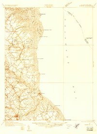 1934 Bowers1934 Print · USGSCoastal Kent County in the mid-1930s is a landscape of tidal marshes and tight-knit farming communities tied to the bay. Researchers can trace ancestral roots at Barratts Chapel, find rural schoolhouses like St Jones Sch, and locate old river settlements like Barkers Landing.
 - 1936 Map of Bowers
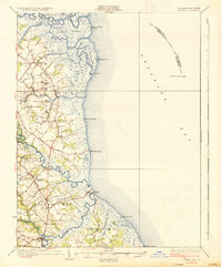 1936 Bowers1936 Print · USGSCoastal Kent County appears in the mid-1930s as a landscape of tidal marshes, small farming districts, and vital river landings. Genealogists can trace family footprints through sites like Barretts Chapel, Barkers Landing, and rural schools like Cowgill Sch.4 unique versions available
 - 1938 Map of Cedar Creek
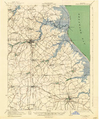 1938 Cedar Creek1938 Print · USGSCoastal Sussex County in the late 1930s shows a landscape of tidal necks and millponds connected by the P B AND W RR. Genealogists can trace family footprints across dozens of local school sites like Wesleys School and the Old Baptist Church.2 unique versions available
End of results
Showing maps 1-3 of 3
Top cities near Frederica
- Dover historical maps
- Milford historical maps
- Highland Acres historical maps
- Harrington historical maps
- Dover Base historical maps
- Woodside East historical maps
See more
Frequently asked questions
- What are the different types of historical maps available for Frederica?
- What is the oldest map of Frederica?
- Where can I purchase historical maps of Frederica for my home or office?
- Where can I download high-res historical maps of Frederica?
- Are there historical topographic maps available for Frederica?
- Is there historical aerial imagery available for Frederica?
- Where are historical maps of Frederica sourced from?