1990s Maps of Milford, Delaware
Explore 2 historic maps of Milford from the 1990s. These maps offer a rare glimpse into what life looked like during the 1990s — showing old roads, neighborhoods, homes, and landmarks that have changed or disappeared over time.
Whether you're researching your family's past, planning a metal detecting trip, or studying how Milford's landscape evolved across the 1990s, these high-resolution maps are a powerful tool for exploring the history of this region.
- Focus on a specific era: All maps on this page are from the 1990s, giving you a focused view of this time period.
- See what’s changed: Compare century-old streets, trails, and buildings to today's modern landscape using overlays and satellite layers.
- Research with precision: Use these maps for genealogy, historical research, land use analysis, or educational projects.
- View, download, or print: Maps are fully viewable online in high resolution, and can be downloaded or printed for your own records.
Start exploring Milford's history through authentic maps from the 1990s. This is your window into the past.
Milford, DE maps
(2)- 1993 Map of Milford
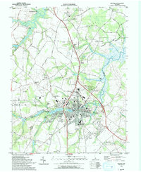 1993 Milford1993 Print · USGSMilford and the Kent-Sussex county line appear here in the early nineties, showing a landscape defined by tidewater rivers and growing residential tracts. Trace local landmarks like the historic Abbotts Mill, the Banneker School, and the waters of Silver Lake.
 - 1993 Map of Mispillion River
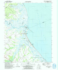 1993 Mispillion River1993 Print · USGSCoastal Sussex County is captured here in the early nineties, where the river meets the bay at the historic Mispillion Light. Researchers can trace local heritage through maritime sites like Fort Saulsbury and old river landings including Revills Landing and Davis Landing.
End of results
Showing maps 1-2 of 2
Top cities near Milford
- Dover historical maps
- Georgetown historical maps
- Highland Acres historical maps
- Harrington historical maps
- Lewes historical maps
- Dover Base historical maps
See more
Top neighborhoods of Milford
Frequently asked questions
- What are the different types of historical maps available for Milford?
- What is the oldest map of Milford?
- Where can I purchase historical maps of Milford for my home or office?
- Where can I download high-res historical maps of Milford?
- Are there historical topographic maps available for Milford?
- Is there historical aerial imagery available for Milford?
- Where are historical maps of Milford sourced from?