1990s Maps of Kings Croft, Bear
Explore 2 historic maps of Kings Croft from the 1990s. These maps offer a rare glimpse into what life looked like during the 1990s — showing old roads, neighborhoods, homes, and landmarks that have changed or disappeared over time.
Whether you're researching your family's past, planning a metal detecting trip, or studying how Kings Croft's landscape evolved across the 1990s, these high-resolution maps are a powerful tool for exploring the history of this region.
- Focus on a specific era: All maps on this page are from the 1990s, giving you a focused view of this time period.
- See what’s changed: Compare century-old streets, trails, and buildings to today's modern landscape using overlays and satellite layers.
- Research with precision: Use these maps for genealogy, historical research, land use analysis, or educational projects.
- View, download, or print: Maps are fully viewable online in high resolution, and can be downloaded or printed for your own records.
Start exploring Kings Croft's history through authentic maps from the 1990s. This is your window into the past.
Kings Croft, Bear maps
(2)- 1993 Map of Newark East
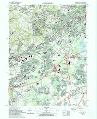 1993 Newark East1993 Print · USGSNewark and the surrounding Delaware suburbs are captured here in the early nineties as modern residential life integrates with historic transport corridors. Researchers can locate community anchors like Delaware Park, All Saints Cemetery, and Goldey Beacom College.2 unique versions available
 - 1993 Map of Saint Georges
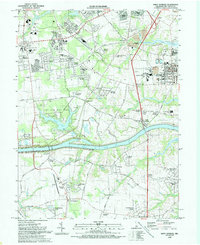 1993 Saint Georges1993 Print · USGSNew Castle County in the early nineties shows the widening contrast between its maritime industrial corridors and expanding residential suburbs. Researchers can trace historic family landmarks and rural infrastructure from Summit Bridge to the quiet Hickory Grove Cemetery and Saint Georges.
End of results
Showing maps 1-2 of 2
Frequently asked questions
- What are the different types of historical maps available for Kings Croft?
- What is the oldest map of Kings Croft?
- Where can I purchase historical maps of Kings Croft for my home or office?
- Where can I download high-res historical maps of Kings Croft?
- Are there historical topographic maps available for Kings Croft?
- Is there historical aerial imagery available for Kings Croft?
- Where are historical maps of Kings Croft sourced from?