1950s Maps of Bridgeville, Delaware
Explore 4 historic maps of Bridgeville from the 1950s. These maps offer a rare glimpse into what life looked like during the 1950s — showing old roads, neighborhoods, homes, and landmarks that have changed or disappeared over time.
Whether you're researching your family's past, planning a metal detecting trip, or studying how Bridgeville's landscape evolved across the 1950s, these high-resolution maps are a powerful tool for exploring the history of this region.
- Focus on a specific era: All maps on this page are from the 1950s, giving you a focused view of this time period.
- See what’s changed: Compare century-old streets, trails, and buildings to today's modern landscape using overlays and satellite layers.
- Research with precision: Use these maps for genealogy, historical research, land use analysis, or educational projects.
- View, download, or print: Maps are fully viewable online in high resolution, and can be downloaded or printed for your own records.
Start exploring Bridgeville's history through authentic maps from the 1950s. This is your window into the past.
Bridgeville, DE maps
(4)- 1955 Map of Seaford East, 1957 Print
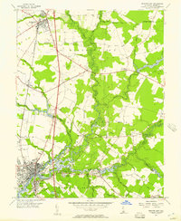 1955 Seaford East1957 Print · USGSSussex County's river-driven geography is captured here in the mid-1950s, centered on the growth of Seaford and Bridgeville. Genealogists and historians can trace old community landmarks like the Frederick Douglass Sch, Chaplins Chapel, and the historic Middleford settlement.2 unique versions available
 - 1955 Map of Greenwood, 1957 Print
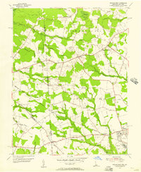
 1955 Greenwood1957 Print · USGSCentral Delaware's Sussex County in the mid-fifties shows a landscape of rail-side towns and marshy woodlots. Trace family roots and local landmarks from Greenwood to Staytonville, including St Johnstown Ch and Devils Woodyard.2 unique versions available
 - 1955 Map of Seaford West, 1957 Print
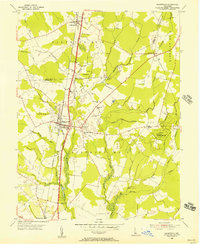
 1955 Seaford West1957 Print · USGSSussex County, Delaware, is captured in the mid-fifties at the Maryland state line, showing a landscape of small crossroads and creek-side industry. Researchers can trace family roots through Old Liberty Ch, Wrights Cem, and the rural Blocksom Sch.2 unique versions available
 - 1957 Map of Salisbury
 1957 Salisbury1957 Print · USGSThe Delmarva Peninsula in the mid-1950s reveals a landscape of coastal defenses and rail-driven commerce. Researchers can trace the Pennsylvania railroad lines or locate historic landmarks like the Fenwick Island Lighthouse and St Martin church.
End of results
Showing maps 1-4 of 4
Top cities near Bridgeville
- Milford historical maps
- Seaford historical maps
- Georgetown historical maps
- Denton historical maps
- Laurel historical maps
- Harrington historical maps
See more
Top neighborhoods of Bridgeville
Frequently asked questions
- What are the different types of historical maps available for Bridgeville?
- What is the oldest map of Bridgeville?
- Where can I purchase historical maps of Bridgeville for my home or office?
- Where can I download high-res historical maps of Bridgeville?
- Are there historical topographic maps available for Bridgeville?
- Is there historical aerial imagery available for Bridgeville?
- Where are historical maps of Bridgeville sourced from?