1950s Maps of Dagsboro, Delaware
Explore 4 historic maps of Dagsboro from the 1950s. These maps offer a rare glimpse into what life looked like during the 1950s — showing old roads, neighborhoods, homes, and landmarks that have changed or disappeared over time.
Whether you're researching your family's past, planning a metal detecting trip, or studying how Dagsboro's landscape evolved across the 1950s, these high-resolution maps are a powerful tool for exploring the history of this region.
- Focus on a specific era: All maps on this page are from the 1950s, giving you a focused view of this time period.
- See what’s changed: Compare century-old streets, trails, and buildings to today's modern landscape using overlays and satellite layers.
- Research with precision: Use these maps for genealogy, historical research, land use analysis, or educational projects.
- View, download, or print: Maps are fully viewable online in high resolution, and can be downloaded or printed for your own records.
Start exploring Dagsboro's history through authentic maps from the 1950s. This is your window into the past.
Dagsboro, DE maps
(4)- 1954 Map of Millsboro, 1955 Print
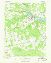 1954 Millsboro1955 Print · USGSMid-century Millsboro and Dagsboro are captured here at a time when the railroad and river still shaped local commerce. Researchers can locate vanished landmarks and rural crossroads like Shaft Ox Corner, Old Field Ch, and the Carey Camp grounds.3 unique versions available
 - 1955 Map of Millsboro
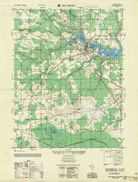 1955 Millsboro1955 Print · USGSSussex County agriculture and river life meet in the mid-fifties along the banks of the Indian River and the Pennsylvania rail line. Researchers can trace old rural centers like Shaft Ox Corner, Carey Camp, and the Old Field Ch.
 - 1955 Map of Frankford, 1956 Print
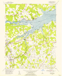 1955 Frankford1956 Print · USGSCoastal Sussex County in the mid-fifties reveals a landscape of tidal necks, railroad towns, and early bayside resorts. Genealogists and historians can trace family-named landmarks and institutions like Antioch Ch, the John M Clayton Sch, and the historic Prince George Chapel.3 unique versions available
 - 1957 Map of Salisbury
 1957 Salisbury1957 Print · USGSThe Delmarva Peninsula in the mid-1950s reveals a landscape of coastal defenses and rail-driven commerce. Researchers can trace the Pennsylvania railroad lines or locate historic landmarks like the Fenwick Island Lighthouse and St Martin church.
End of results
Showing maps 1-4 of 4
Top cities near Dagsboro
- Ocean Pines historical maps
- Ocean City historical maps
- West Ocean City historical maps
- Georgetown historical maps
- Berlin historical maps
- Lewes historical maps
See more
Top neighborhoods of Dagsboro
Frequently asked questions
- What are the different types of historical maps available for Dagsboro?
- What is the oldest map of Dagsboro?
- Where can I purchase historical maps of Dagsboro for my home or office?
- Where can I download high-res historical maps of Dagsboro?
- Are there historical topographic maps available for Dagsboro?
- Is there historical aerial imagery available for Dagsboro?
- Where are historical maps of Dagsboro sourced from?