1910s Maps of Dagsboro, Delaware
Explore 2 historic maps of Dagsboro from the 1910s. These maps offer a rare glimpse into what life looked like during the 1910s — showing old roads, neighborhoods, homes, and landmarks that have changed or disappeared over time.
Whether you're researching your family's past, planning a metal detecting trip, or studying how Dagsboro's landscape evolved across the 1910s, these high-resolution maps are a powerful tool for exploring the history of this region.
- Focus on a specific era: All maps on this page are from the 1910s, giving you a focused view of this time period.
- See what’s changed: Compare century-old streets, trails, and buildings to today's modern landscape using overlays and satellite layers.
- Research with precision: Use these maps for genealogy, historical research, land use analysis, or educational projects.
- View, download, or print: Maps are fully viewable online in high resolution, and can be downloaded or printed for your own records.
Start exploring Dagsboro's history through authentic maps from the 1910s. This is your window into the past.
Dagsboro, DE maps
(2)- 1917 Map of Millsboro
 1917 Millsboro1917 Print · USGSCoastal Sussex County is captured here during the First World War, showing a landscape of rural schoolhouses and railroad sidings centered on Georgetown. Genealogists can trace family connections through numerous landmarks like Mc Colleys, Shortly, and the Westwood Church.2 unique versions available
 - 1918 Map of Rehoboth
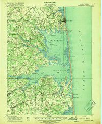 1918 Rehoboth1918 Print · USGSCoastal Sussex County is seen here at the close of the Great War, when small farming villages still outnumbered beach resorts. Genealogists can trace family roots through numerous rural landmarks like Trinity Church, Eldorado School, and the Grange Hall.8 unique versions available
End of results
Showing maps 1-2 of 2
Top cities near Dagsboro
- Ocean Pines historical maps
- Ocean City historical maps
- West Ocean City historical maps
- Georgetown historical maps
- Berlin historical maps
- Lewes historical maps
See more
Top neighborhoods of Dagsboro
Frequently asked questions
- What are the different types of historical maps available for Dagsboro?
- What is the oldest map of Dagsboro?
- Where can I purchase historical maps of Dagsboro for my home or office?
- Where can I download high-res historical maps of Dagsboro?
- Are there historical topographic maps available for Dagsboro?
- Is there historical aerial imagery available for Dagsboro?
- Where are historical maps of Dagsboro sourced from?