
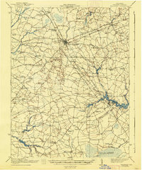
1917 Map of Millsboro
USGS Topo · Published 1917About this map
Georgetown serves as the central hub of this Sussex County landscape during the Great War era, positioned where the Pennsylvania Railroad intersects a complex network of named ditches and branches. The settlement pattern is defined by dozens of crossroads and small family-named stops such as Redden Crossroads, Jones Crossroads, and Shortly. This survey reveals a high density of rural institutions, with more than thirty individual schools like the Isaacs School and Mission Hill School scattered across the interior. To the east, the headwaters of the Indian River form at Millsboro, where Millsboro Pond and Betts Pond collect the waters of the Stockley Branch and Vines Branch. Significant wetland areas like the Cedar Creek and the Pocomoke River headwaters dominate the southern terrain, illustrating the hydrological management through projects like the Mifflin Ditch and Layton Ditch.
Find a feature on this map
100 named features on this map. Tap any name to fly to it.
Don’t see what you’re looking for? This feature index may not catch every label — zoom into the map to look around manually.
Map Details
Editions of this 1917 Millsboro Map
2 editions found
Other maps of this area

1901 · Salisbury
USGS Topo · 1:62,500

1901 · Ocean City
USGS Topo · 1:62,500

1902 · Pittsville
USGS Topo · 1:62,500

1915 · Seaford
USGS Topo · 1:62,500

1918 · Cedar Creek
USGS Topo · 1:62,500

1918 · Harrington
USGS Topo · 1:62,500

1918 · Rehoboth
USGS Topo · 1:62,500

1918 · Cape Henlopen
USGS Topo · 1:62,500

1919 · Cedar Creek
USGS Topo · 1:62,500

1937 · Cape Henlopen
USGS Topo · 1:62,500