
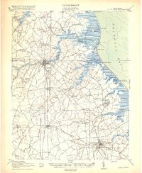
1918 Map of Cedar Creek
USGS Topo · Published 1918About this map
Sussex County's coastal landscape is defined by the heavy marshlands and high peninsulas of the Delaware Bay shoreline, as surveyed just before the end of the First World War. The region is divided by distinct necks of land, most notably Mispillion Neck and Slaughter Neck, where early maritime commerce centered on the Mispillion River and its lighthouse, Mispillion River LH. In the interior, the P. B. and W. RR links the thriving centers of Milford and Milton, while a dense network of country schools like Sour Apple Tree School and Shingle School serves the surrounding timber and agricultural lands.
Find a feature on this map
87 named features on this map. Tap any name to fly to it.
Don’t see what you’re looking for? This feature index may not catch every label — zoom into the map to look around manually.
Map Details
Editions of this 1918 Cedar Creek Map
2 editions found
Other maps of this area

1890 · Maurice Cove
USGS Topo · 1:62,500

1891 · Maurice Cove
USGS Topo · 1:62,500

1899 · Vineland
USGS Topo · 1:125,000

1899 · Dover
USGS Topo · 1:125,000

1906 · Dover
USGS Topo · 1:125,000

1915 · Seaford
USGS Topo · 1:62,500

1917 · Millsboro
USGS Topo · 1:62,500

1918 · Harrington
USGS Topo · 1:62,500

1918 · Rehoboth
USGS Topo · 1:62,500

1918 · Cape Henlopen
USGS Topo · 1:62,500