
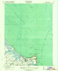
1918 Map of Cape Henlopen
USGS Topo · Published 1918About this map
Lewes serves as the focal point for this maritime landscape at the mouth of the Delaware Bay, where the coastline curves toward the Atlantic Ocean. During this period just after the Great War, the area functioned as a vital naval and commercial junction, anchored by the Breakwater Harbor and the Harbor of Refuge. The map reveals an intricate network of coastal navigation aids, including the Cape Henlopen Light and Brandywine Shoal Light, alongside a Quarantine station and multiple Coast Guard stations. Inland, the economy is defined by the convergence of the Maryland Delaware and Virginia and Philadelphia Baltimore and Washington railroads. Small crossroads like Wescoat Corners and Murray Corners suggest a rural interior supporting the busy port, while features like Red Mill Pond and the West Hill School provide a look at the social and industrial layout of Sussex County before significant modern development.
Find a feature on this map
27 named features on this map. Tap any name to fly to it.
Don’t see what you’re looking for? This feature index may not catch every label — zoom into the map to look around manually.
Map Details
Editions of this 1918 Cape Henlopen Map
2 editions found
Other maps of this area

1888 · Cape May
USGS Topo · 1:62,500

1888 · Dennisville
USGS Topo · 1:62,500

1890 · Maurice Cove
USGS Topo · 1:62,500

1891 · Maurice Cove
USGS Topo · 1:62,500

1893 · Cape May
USGS Topo · 1:62,500

1894 · Dennisville
USGS Topo · 1:62,500

1898 · Cape May
USGS Topo · 1:62,500

1899 · Vineland
USGS Topo · 1:125,000

1917 · Millsboro
USGS Topo · 1:62,500

1918 · Cedar Creek
USGS Topo · 1:62,500