1940s Maps of Selbyville, Delaware
Explore 7 historic maps of Selbyville from the 1940s. These maps offer a rare glimpse into what life looked like during the 1940s — showing old roads, neighborhoods, homes, and landmarks that have changed or disappeared over time.
Whether you're researching your family's past, planning a metal detecting trip, or studying how Selbyville's landscape evolved across the 1940s, these high-resolution maps are a powerful tool for exploring the history of this region.
- Focus on a specific era: All maps on this page are from the 1940s, giving you a focused view of this time period.
- See what’s changed: Compare century-old streets, trails, and buildings to today's modern landscape using overlays and satellite layers.
- Research with precision: Use these maps for genealogy, historical research, land use analysis, or educational projects.
- View, download, or print: Maps are fully viewable online in high resolution, and can be downloaded or printed for your own records.
Start exploring Selbyville's history through authentic maps from the 1940s. This is your window into the past.
Selbyville, DE maps
(7)- 1942 Map of Ocean City
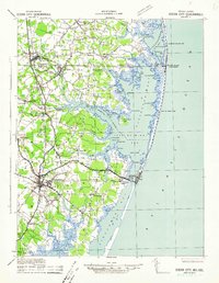 1942 Ocean City1942 Print · USGSThe Maryland and Delaware coastline at the onset of the 1940s reveals a region of tidal bays and rail-dependent coastal towns. Genealogists and historians can trace family roots in early settlements like Berlin, Sinepuxent, and Bishopville or locate maritime landmarks including Fenwick Island Lighthouse.2 unique versions available
 - 1942 Map of Whaleysville, 1962 Print
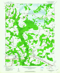 1942 Whaleysville1962 Print · USGSThe Maryland and Delaware borderlands were defined by the rail-and-water economy during the early 1940s. Genealogists and local historians can trace the foundations of communities like Whaleysville and Willards, along with rural landmarks like Pulletts Chapel and Newhope Cem.3 unique versions available
 - 1943 Map of Selbyville
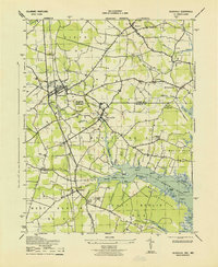 1943 Selbyville1943 Print · USGSDelaware and Maryland borderlands come to life in this mid-century survey of the Selbyville area, showing the region just as wartime mapping efforts reached their peak. Genealogists can trace family footprints through historic centers like Bishopville, Showell, and St Martins Church.2 unique versions available
 - 1943 Map of Whaleysville
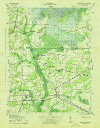 1943 Whaleysville1943 Print · USGSThe Maryland-Delaware border region in the early 1940s was a landscape defined by the drainage of the Cypress Swamp and the Pocomoke River. Researchers can locate historic rural landmarks including Pilgrim Church, Pulletts Chapel, and the Newhope Cem.
 - 1946 Map of Salisbury, 1948 Print
 1946 Salisbury1948 Print · USGSThe Delmarva Peninsula in the late nineteen-forties shows a landscape defined by its deep river arteries and emerging coastal defenses. Genealogists and historians can trace rail-connected towns like Federalsburg or locate maritime landmarks such as the Ocean City Seaplane Base and Fort Miles Military Reservation.4 unique versions available
 - 1947 Map of Salisbury, 1948 Print
 1947 Salisbury1948 Print · USGSThe Delmarva Peninsula in the late forties reveals a coastal landscape of maritime defense and growing seaside towns. Trace the post-war footprint of Salisbury, the strategic Fort Miles Military Reservation, and the Ocean City Seaplane Base.
 - 1948 Map of Salisbury, 1951 Print
 1948 Salisbury1951 Print · USGSThe Delmarva Peninsula in the late 1940s is shown here as a busy network of rail-towns and coastal outposts. Researchers can trace the legacy of the Pennsylvania Railroad through inland hubs like Georgetown or the maritime reaches of Crisfield and Cape May.
End of results
Showing maps 1-7 of 7
Top cities near Selbyville
- Ocean Pines historical maps
- Ocean City historical maps
- West Ocean City historical maps
- Georgetown historical maps
- Berlin historical maps
- Millsboro historical maps
See more
Top neighborhoods of Selbyville
Frequently asked questions
- What are the different types of historical maps available for Selbyville?
- What is the oldest map of Selbyville?
- Where can I purchase historical maps of Selbyville for my home or office?
- Where can I download high-res historical maps of Selbyville?
- Are there historical topographic maps available for Selbyville?
- Is there historical aerial imagery available for Selbyville?
- Where are historical maps of Selbyville sourced from?