Old Maps of Marion County, Florida
Explore 293 old maps of Marion County, spanning from 1892 to today. These high-resolution historic maps reveal how streets, neighborhoods, landmarks, and natural features evolved over time — perfect for genealogy, metal detecting, research, and local history exploration.
What you can do with these maps:
- See how Marion County changed over time: Compare historical maps to modern-day views to trace roads, homesites, rail lines & more.
- View detailed metadata: Each map includes creators, publishers, year, scale, and archive source.
- Overlay maps with satellite & LiDAR: Visualize the past alongside modern tools to explore terrain & human change.
- Trusted historical sources: Maps sourced from the USGS, Library of Congress, and other archives.
- Access maps your way: View online, download high-res files, or order prints for personal or research use.
Start exploring old maps of Marion County to uncover forgotten places, hidden landmarks, and the deep history beneath your feet.
Marion County, FL maps
(293)- 1892 Map of Dunnellon
 1892 Dunnellon1892 Print · USGSMarion and Levy counties were at the center of a phosphate boom in the early 1890s, anchored by the riverfront settlement of Dunnellon. Researchers can trace the early industrial footprint of Eagle Mines, find rural community hubs like Cotton Plant, and locate historical crossings such as Fish Ferry.
 - 1893 Map of Panasoffkee, 1958 Print
 1893 Panasoffkee1958 Print · USGSSumter County was a landscape of expansive wetlands and early rail outposts during the 1890s. Genealogists and historians can trace the early rail stops at Wildwood and Coleman or locate historic waters like Lake Panasoffkee and Warm Spring.
 - 1893 Map of Citra, 1960 Print
 1893 Citra1960 Print · USGSMarion County in the late nineteenth century was a hub of industrial mining and railroad expansion. Genealogists and historians can trace the early phosphate boom at the French Phosphate Mines or locate old rail stops in Citra, McIntosh, and Anthony.
 - 1894 Map of Dunnellon
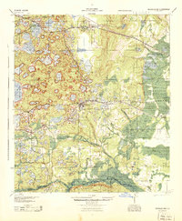
 1894 Dunnellon1894 Print · USGSMarion and Citrus counties were centers of a burgeoning phosphate boom in the early 1890s, where river and rail infrastructure converged. You can trace early mining operations like the Chicago Mine and Eagle Mine alongside historic river crossings at Fisk Ferry.5 unique versions available
 - 1895 Map of Williston
 1895 Williston1895 Print · USGSNorth Central Florida in the mid-1890s reveals a landscape shaped by phosphate mining and the arrival of the iron horse. Genealogists and historians can trace early rail hubs like Williston and Montbrook, alongside industrial sites like Standard Mine and Phosphate.6 unique versions available
 - 1895 Map of Tsala Apopka
 1895 Tsala Apopka1895 Print · USGSCentral Florida's interior in the early 1890s was a landscape of citrus groves and pine hills meeting the labyrinth of the Tsala Apopka Lake system. Researchers can trace early railroad towns like Hernando and Mannfield alongside river landmarks such as Stokes Ferry and the Hamburg Mine.7 unique versions available
 - 1895 Map of Citra
 1895 Citra1895 Print · USGSNorthern Marion County and southern Alachua County are shown here in the 1890s, when phosphate mining and citrus transport drove the local economy. Trace the old rail lines and explore the sites of the French Phosphate Mines, Citra, and McIntosh.6 unique versions available
 - 1895 Map of Panasoffkee
 1895 Panasoffkee1895 Print · USGSSumter County in the 1890s reveals a landscape of expansive wetlands and emerging rail towns. Genealogists and local historians can trace early settlements like Royal and Oxford or follow the route of the Florida Central and Peninsular RR.5 unique versions available
 - 1895 Map of Ocala
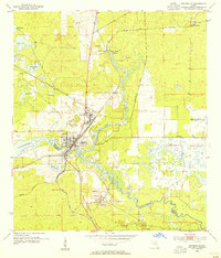
 1895 Ocala1895 Print · USGSMarion County at the end of the nineteenth century was a bustling intersection of rail and water. Researchers can trace the early footprints of Ocala and Silver Springs, or locate smaller stops along the Florida Southern R. R. like Santos and Belleview.7 unique versions available
 - 1915 Map of Interlachen
 1915 Interlachen1915 Print · USGSThe Florida interior around the lake-heavy Putnam and Marion county lines is shown here in the years before widespread drainage and development. Researchers can trace the early rail stops at Florahome and Mannville or locate rural landmarks like Magnolia Church and the Cedar Landing Ferry.
 - 1916 Map of Interlachen
 1916 Interlachen1916 Print · USGSFlorida's lake-filled interior at the start of the Great War is a landscape of scattered rail towns and expansive wetlands. Genealogists and local historians can trace family roots through old settlements like Interlachen, Putnam Hall, and Kenwood Heights, or locate the rural Roscola School and Conch School.6 unique versions available
 - 1938 Map of Hawthorn
 1938 Hawthorn1938 Print · USGSAlachua County in the late thirties is a landscape of intersecting railroads and sprawling lakeside settlements. Genealogists and historians can trace the foundations of Hawthorn, locate remote burial sites like Riley Cem, and explore the rail junctions at Micanopy Junction.
 - 1943 Map of Hawthorn, 1963 Print
 1943 Hawthorn1963 Print · USGSAlachua County during the early war years reveals a landscape defined by its great lakes and a dual-railroad economy. Researchers can trace the routes of the Seaboard Air Line, locate rural landmarks like Ochwilla Church, or find family roots at Providence Cem and Drummond Cem.
 - 1944 Map of Interlachen
 1944 Interlachen1944 Print · USGSNorth-central Florida's rail-and-water network is captured here in the 1940s, centered on the bustling junction at Interlachen. Genealogists and historians can trace riverside activity at Cedar Landing Ferry and early rural education sites like Congo Sch.
 - 1949 Map of Keuka, 1953 Print
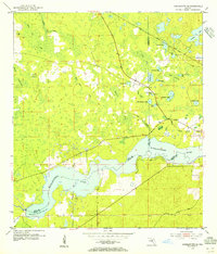
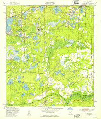 1949 Keuka1953 Print · USGSFlorida's lake country near the Marion and Putnam county line was a network of river landings and rail stops in the late 1940s. Genealogists and historians can trace community roots at Edgar Community Ch, find old crossings like Brumbridge Ferry, and locate early riverfront points at Agnews Landing.6 unique versions available
 - 1949 Map of Rodman, 1953 Print
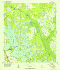
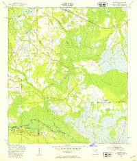 1949 Rodman1953 Print · USGSInland Florida in the late 1940s was a land of timber mills and riverfront landings. Trace the early boundaries of the Ocala National Forest and locate historical sites like Rainbow Ranch, Rodman, and the riverside Cedar Landing.3 unique versions available
 - 1949 Map of Interlachen, 1955 Print
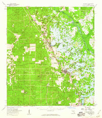
 1949 Interlachen1955 Print · USGSPutnam County's lake-rich interior is captured here just after the war, showing the distinct citrus and rail-centered settlements of the era. Genealogists can locate family landmarks like Mt Bethel Ch, Johnson Park Sch, and the unique Peat Cuttings near Florahome.3 unique versions available
 - 1954 Map of Romeo, 1955 Print
 1954 Romeo1955 Print · USGSMarion and Levy counties in the mid-1950s show a landscape of rail-dependent settlements and seasonal prairies. Genealogists and historians can trace families near Romeo or Hoyt, and locate the historic Zion Hill Cem and Zion Hill Ch.2 unique versions available
 - 1954 Map of Tsala Apopka NE, 1955 Print
 1954 Tsala Apopka NE1955 Print · USGSMid-century Citrus County is defined here by the intricate wetlands and rail lines that once fueled the local economy. Genealogists and historians can trace the foundations of Hernando and locate rural landmarks like Stokes Ferry and Twomile Prairie Lake.5 unique versions available
 - 1954 Map of Dunnellon, 1955 Print
 1954 Dunnellon1955 Print · USGSDunnellon and the surrounding phosphate mining district come into sharp focus in the mid-1950s. Trace the rail-and-river history of the region through the Atlantic Coast Line, the Rockwell Cem, and the Dunnellon Airport (Abandoned).3 unique versions available
 - 1954 Map of Cotton Plant, 1955 Print
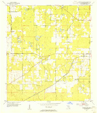 1954 Cotton Plant1955 Print · USGSMarion County in the mid-fifties is a landscape of rural settlements and intersecting rail lines. Genealogists and historians can locate old churches and community centers like Mars Hill Ch, Cotton Plant, and the railway siding at Martel.2 unique versions available
 - 1954 Map of Dunnellon SE, 1955 Print
 1954 Dunnellon SE1955 Print · USGSMarion County in the mid-1950s reveals the interrupted dream of a trans-Florida waterway. Researchers can trace the path of the Proposed Gulf Atlantic Ship Canal (Abandoned) and locate landmarks like Cedar Grove Ch and the Dunnellon Airport (Abandoned).2 unique versions available
 - 1954 Map of Yankeetown SE, 1955 Print
 1954 Yankeetown SE1955 Print · USGSThe Florida hammock country comes into focus in the mid-1950s as the Withlacoochee River flows through the convergence of three counties. You can trace the Atlantic Coast Line rail route and locate secluded landmarks like Lebanon Cem and Dog Ear Cem.3 unique versions available
 - 1954 Map of Inverness, 1960 Print
 1954 Inverness1960 Print · USGSMid-century Citrus County is defined by the intricate wetlands and island communities of the lake region. Genealogists and historians can trace the paths of the Atlantic Coast Line through Hernando or locate the Dampier Cemetery and the Poor Farm Landing Field.2 unique versions available
 - 1954 Map of Dunnellon, 1960 Print
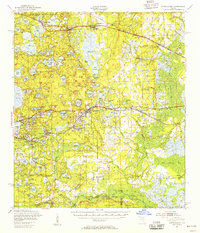
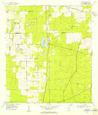
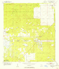
 1954 Dunnellon1960 Print · USGSDunnellon and rural Marion County appear in the mid-1950s as a landscape of phosphate mining, railroads, and fresh water springs. Genealogists and historians can trace family locations near Zion Hill Cem, Cotton Plant, and the Circle Square Ranch.
Showing maps 1-25 of 293
Top cities of Marion County
- Ocala historical maps
- Citra historical maps
- Rainbow Springs historical maps
- Belleview historical maps
- Dunnellon historical maps
- Reddick historical maps
See more
Frequently asked questions
- What are the different types of historical maps available for Marion County?
- What is the oldest map of Marion County?
- Where can I purchase historical maps of Marion County for my home or office?
- Where can I download high-res historical maps of Marion County?
- Are there historical topographic maps available for Marion County?
- Is there historical aerial imagery available for Marion County?
- Where are historical maps of Marion County sourced from?