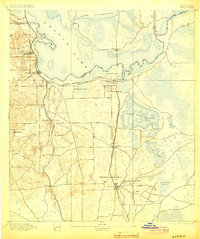
1895 Map of Citra
USGS Topo · Published 1903About this map
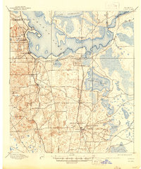
Phosphate mining and citrus cultivation define this north-central Florida landscape at the end of the nineteenth century. The town of Citra sits at a critical junction where the Florida Southern R. R. and the Florida Central and Peninsular R. R. meet, facilitating the shipment of regional goods. To the south, the industrial presence of the French Phosphate Mines, Baker Mine, and Excelsior Mine near Anthony indicates the area's economic reliance on mineral extraction.
Find a feature on this map
32 named features on this map. Tap any name to fly to it.
Don’t see what you’re looking for? This feature index may not catch every label — zoom into the map to look around manually.
Map Details
Editions of this 1895 Citra Map
6 editions found
Other maps of this area

1890 · Arredondo
USGS Topo · 1:62,500

1892 · Dunnellon
USGS Topo · 1:62,500

1892 · Arredondo
USGS Topo · 1:62,500

1893 · Citra
USGS Topo · 1:62,500

1894 · Dunnellon
USGS Topo · 1:62,500

1894 · Arredondo
USGS Topo · 1:62,500

1895 · Williston
USGS Topo · 1:62,500

1895 · Citra
USGS Topo · 1:62,500

1895 · Ocala
USGS Topo · 1:62,500

1915 · Interlachen
USGS Topo · 1:48,000