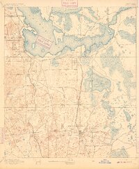
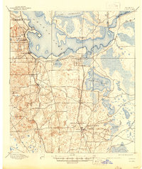
1895 Map of Citra
USGS Topo · Published 1909About this map
Phosphate mining and citrus cultivation define this late-19th-century landscape at the junction of Marion and Alachua counties. The southern reaches of the sheet reveal an burgeoning industrial corridor near Anthony, home to the French Phosphate Mines, Baker Mine, and Excelsior Mine. This resource extraction is supported by the intersecting lines of the Florida Central And Peninsular R. R. and the Florida Southern R. R., which connect the interior settlements of Citra and Reddick to the wider region.
Find a feature on this map
31 named features on this map. Tap any name to fly to it.
Don’t see what you’re looking for? This feature index may not catch every label — zoom into the map to look around manually.
Map Details
Editions of this 1895 Citra Map
6 editions found
Other maps of this area

1890 · Arredondo
USGS Topo · 1:62,500

1892 · Dunnellon
USGS Topo · 1:62,500

1892 · Arredondo
USGS Topo · 1:62,500

1893 · Citra
USGS Topo · 1:62,500

1894 · Dunnellon
USGS Topo · 1:62,500

1894 · Arredondo
USGS Topo · 1:62,500

1895 · Williston
USGS Topo · 1:62,500

1895 · Citra
USGS Topo · 1:62,500

1895 · Ocala
USGS Topo · 1:62,500

1915 · Interlachen
USGS Topo · 1:48,000