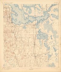
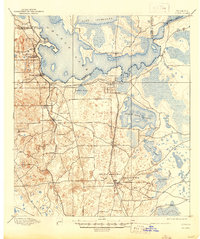
1895 Map of Citra
USGS Topo · Published 1929About this map
Orange Lake and the surrounding wetlands dominate this late-19th-century landscape on the border of Alachua and Marion Counties. The region is characterized by expansive seasonal water bodies like Black Sink Prairie, Hawthorn Prairie, and Goneski Prairie, illustrating the unique hydrology of central Florida before modern drainage and development altered these basins. Two major rail lines, the Florida Southern R. R. and the Florida Central and Peninsular, provide the primary infrastructure for the citrus and mining economies.
Find a feature on this map
32 named features on this map. Tap any name to fly to it.
Don’t see what you’re looking for? This feature index may not catch every label — zoom into the map to look around manually.
Map Details
Editions of this 1895 Citra Map
6 editions found
Other maps of this area

1890 · Arredondo
USGS Topo · 1:62,500

1892 · Dunnellon
USGS Topo · 1:62,500

1892 · Arredondo
USGS Topo · 1:62,500

1893 · Citra
USGS Topo · 1:62,500

1894 · Dunnellon
USGS Topo · 1:62,500

1894 · Arredondo
USGS Topo · 1:62,500

1895 · Williston
USGS Topo · 1:62,500

1895 · Citra
USGS Topo · 1:62,500

1895 · Ocala
USGS Topo · 1:62,500

1915 · Interlachen
USGS Topo · 1:48,000