1910s Maps of Baker County, Florida
Explore 4 historic maps of Baker County from the 1910s. These maps offer a rare glimpse into what life looked like during the 1910s — showing old roads, neighborhoods, homes, and landmarks that have changed or disappeared over time.
Whether you're researching your family's past, planning a metal detecting trip, or studying how Baker County's landscape evolved across the 1910s, these high-resolution maps are a powerful tool for exploring the history of this region.
- Focus on a specific era: All maps on this page are from the 1910s, giving you a focused view of this time period.
- See what’s changed: Compare century-old streets, trails, and buildings to today's modern landscape using overlays and satellite layers.
- Research with precision: Use these maps for genealogy, historical research, land use analysis, or educational projects.
- View, download, or print: Maps are fully viewable online in high resolution, and can be downloaded or printed for your own records.
Start exploring Baker County's history through authentic maps from the 1910s. This is your window into the past.
Baker County, FL maps
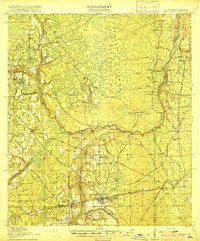
(4)- 1917 Map of Macclenny, 1967 Print
 1917 Macclenny1967 Print · USGSThe Florida-Georgia borderlands come to life in the years before the Great War, showing the rail junctions and river crossings that shaped Baker County. Genealogists can trace family roots through numerous local landmarks like Sings Still, Macedon Church, and Garrett School.
 - 1918 Map of Moniac
 1918 Moniac1918 Print · USGSThe borderlands of Georgia and Florida come alive in this 1917 survey of the Okeefenokee fringe and the St. Marys River. Researchers can trace the railroad economy through St George and Moniac, or locate family sites like Olivers Mill and the Chesser School.2 unique versions available
 - 1918 Map of Lawtey
 1918 Lawtey1918 Print · USGSFlorida's northern interior during the First World War reveals a landscape of isolated farmsteads and growing rail towns. Researchers can locate early schoolhouses like Ben Rowe School and Vanderbilt School or trace the early footprint of the Bradford Farms (State Prison).5 unique versions available
 - 1918 Map of Macclenny
 1918 Macclenny1918 Print · USGSThe Florida-Georgia borderlands come to life in this World War I-era survey of the pine flatwoods and river prongs. Researchers can trace early family sites like Macclenny and Glen St Mary, alongside rural landmarks such as Hicks Church and Suggs Still.4 unique versions available
End of results
Showing maps 1-4 of 4
Top cities of Baker County
Frequently asked questions
- What are the different types of historical maps available for Baker County?
- What is the oldest map of Baker County?
- Where can I purchase historical maps of Baker County for my home or office?
- Where can I download high-res historical maps of Baker County?
- Are there historical topographic maps available for Baker County?
- Is there historical aerial imagery available for Baker County?
- Where are historical maps of Baker County sourced from?