1960s Maps of Baker County, Florida
Explore 9 historic maps of Baker County from the 1960s. These maps offer a rare glimpse into what life looked like during the 1960s — showing old roads, neighborhoods, homes, and landmarks that have changed or disappeared over time.
Whether you're researching your family's past, planning a metal detecting trip, or studying how Baker County's landscape evolved across the 1960s, these high-resolution maps are a powerful tool for exploring the history of this region.
- Focus on a specific era: All maps on this page are from the 1960s, giving you a focused view of this time period.
- See what’s changed: Compare century-old streets, trails, and buildings to today's modern landscape using overlays and satellite layers.
- Research with precision: Use these maps for genealogy, historical research, land use analysis, or educational projects.
- View, download, or print: Maps are fully viewable online in high resolution, and can be downloaded or printed for your own records.
Start exploring Baker County's history through authentic maps from the 1960s. This is your window into the past.
Baker County, FL maps
(9)- 1963 Map of Olustee, 1964 Print
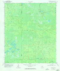
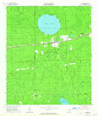 1963 Olustee1964 Print · USGSBaker County at the dawn of the sixties remains a landscape of dense pine woods and significant Civil War heritage. Researchers can trace the rail lines of the Seaboard Air Line or locate family sites near Dyess Cem and the Olustee Battlefield State Mon.3 unique versions available
 - 1963 Map of Sanderson South, 1964 Print
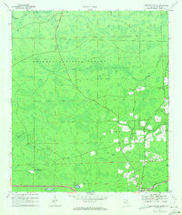
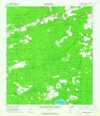 1963 Sanderson South1964 Print · USGSNorth Florida's timber and rail country is captured in the early sixties, showing the vital connection between the Osceola National Forest and the Seaboard Air Line. Genealogists can locate the Bethlehem Cem and trace early crossroads near Sanderson and Manns Spur.2 unique versions available
 - 1967 Map of Moniac, 1968 Print
 1967 Moniac1968 Print · USGSThe Georgia-Florida state line meets the great swamp in the late sixties, where the river and rail lines converge. Trace local history at Moniac and Baxter, find the Moniac Cem, or follow the Dismantled Logging Tram through the marsh.
 - 1967 Map of Sargent, 1968 Print
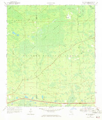
 1967 Sargent1968 Print · USGSThe Georgia-Florida borderlands come alive in this late-sixties experimental survey, where the great southern swamps meet the rail line. Researchers can trace the Southern railroad through the Okefenokee Swamp past Sargent and Moorehead.
 - 1967 Map of Eddy, 1968 Print
 1967 Eddy1968 Print · USGSThe Florida-Georgia borderlands near the Okefenokee Swamp are captured in the late 1960s, showing a remote landscape of wetlands and rails. Trace the path of the Southern railroad past the Radio Lookout Tower and islands like Mitchell Island.
 - 1969 Map of Sanderson NW, 1971 Print
 1969 Sanderson NW1971 Print · USGSUpper Baker County in the late sixties remains a wilderness of vast wetlands and timber tracks within the Osceola National Forest. Outdoorsmen and researchers can trace the old routes of Sand Hill Road and find isolated landmarks like Negro Camp Island and Buck Island Lake.3 unique versions available
 - 1969 Map of Sanderson North, 1971 Print
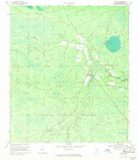
 1969 Sanderson North1971 Print · USGSBaker County in the late 1960s was a landscape of dense national forest and quiet rail-side communities. Genealogists and historians can trace family locations near Sanderson, finding local landmarks like Cedar Creek Ch (Cem) and the Central Sch.2 unique versions available
 - 1969 Map of Big Gum Swamp, 1971 Print
 1969 Big Gum Swamp1971 Print · USGSThe Florida-Georgia borderlands in the late sixties were defined by the deep woods of the Osceola National Forest. Researchers can trace the hydrology of the St Marys River headwaters and find forest locations like Seventeenmile Camp and Big Island.3 unique versions available
 - 1969 Map of Taylor, 1971 Print
 1969 Taylor1971 Print · USGSIn the late sixties, the northern reaches of Baker County were a mosaic of timberland and deep wetlands within the Osceola National Forest. Researchers can trace the community around Taylor, locate the Pleasant Grove Ch, and identify remote landmarks like the Lookout Tower and Huckleberry Island.3 unique versions available
End of results
Showing maps 1-9 of 9
Top cities of Baker County
Frequently asked questions
- What are the different types of historical maps available for Baker County?
- What is the oldest map of Baker County?
- Where can I purchase historical maps of Baker County for my home or office?
- Where can I download high-res historical maps of Baker County?
- Are there historical topographic maps available for Baker County?
- Is there historical aerial imagery available for Baker County?
- Where are historical maps of Baker County sourced from?