Old Maps of Baker County, Florida for Academic Research
Study the evolution of Baker County with 113 high-resolution historic maps. Whether you're teaching, researching, or modeling changes in land use, these maps provide essential visual documentation of urban, environmental, and geographic change.
- Analyze long-term change: Track patterns in development, transportation, and natural features.
- Ideal for environmental or urban studies: Support academic projects with primary historical map data.
- Use in the classroom or lab: Educators and researchers rely on these maps to bring historical context to life.
These maps are a powerful tool for teaching, research, and visualizing how Baker County has changed over the decades.
Baker County, FL maps
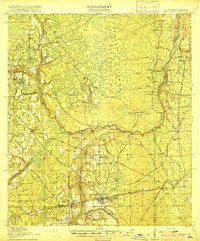
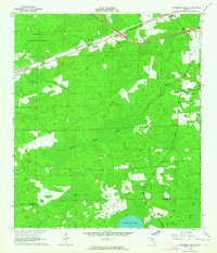
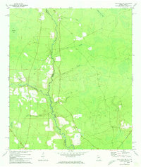
(113)- 1917 Map of Macclenny, 1967 Print
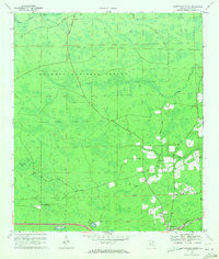
 1917 Macclenny1967 Print · USGSThe Florida-Georgia borderlands come to life in the years before the Great War, showing the rail junctions and river crossings that shaped Baker County. Genealogists can trace family roots through numerous local landmarks like Sings Still, Macedon Church, and Garrett School.
 - 1918 Map of Moniac
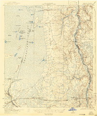
 1918 Moniac1918 Print · USGSThe borderlands of Georgia and Florida come alive in this 1917 survey of the Okeefenokee fringe and the St. Marys River. Researchers can trace the railroad economy through St George and Moniac, or locate family sites like Olivers Mill and the Chesser School.2 unique versions available
 - 1918 Map of Lawtey
 1918 Lawtey1918 Print · USGSFlorida's northern interior during the First World War reveals a landscape of isolated farmsteads and growing rail towns. Researchers can locate early schoolhouses like Ben Rowe School and Vanderbilt School or trace the early footprint of the Bradford Farms (State Prison).5 unique versions available
 - 1918 Map of Macclenny
 1918 Macclenny1918 Print · USGSThe Florida-Georgia borderlands come to life in this World War I-era survey of the pine flatwoods and river prongs. Researchers can trace early family sites like Macclenny and Glen St Mary, alongside rural landmarks such as Hicks Church and Suggs Still.4 unique versions available
 - 1942 Map of Moniac
 1942 Moniac1942 Print · USGSThe Georgia-Florida borderlands were defined by the wilderness of the Okefenokee Swamp and the tracks of the Georgia Southern and Florida railroad. Genealogists and historians can locate old landmarks like Olivers Mill, Deep Creek Church, and several rural schools including Chesser School and Dunn Creek School.2 unique versions available
 - 1954 Map of Valdosta, 1967 Print
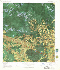
 1954 Valdosta1967 Print · USGSThe South Georgia and North Florida borderlands are captured here in the mid-fifties, showing the deep timber and wetland networks of the coastal plain. Researchers can trace the path of the Atlantic Coast Line through Valdosta or explore the interior of the Okefenokee Swamp.2 unique versions available
 - 1956 Map of Eddy, 1957 Print
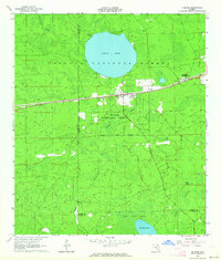
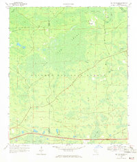
 1956 Eddy1957 Print · USGSThe Florida-Georgia borderlands are captured here in the mid-1950s, dominated by the intersection of rail transit and vast wetlands. You can trace the Southern railroad through the settlement of Eddy and locate the Eddy Lookout Tower deep within the Okefenokee Swamp.
 - 1956 Map of Sargent, 1957 Print
 1956 Sargent1957 Print · USGSThe Florida-Georgia borderlands are captured here in the mid-1950s, highlighting the wild interior where the Southern railroad bisects the great swamps. Trace the isolated outposts of Sargent and Ewing or explore the drainage of White Arm Bay.
 - 1958 Map of Valdosta
 1958 Valdosta1958 Print · USGSSouth Georgia and North Florida are captured here in the mid-fifties, showing the vast Okefenokee Swamp and the vital timber and rail corridors connecting the two states. Researchers can locate the footprint of Moody Air Force Base, trace the Live Oak Perry and Gulf railroad, or find early community sites like Bakers Mill and Paradise Church.
 - 1959 Map of Valdosta
 1959 Valdosta1959 Print · USGSThe Georgia-Florida borderlands in the mid-fifties reveal a landscape of massive blackwater swamps and emerging military aviation hubs. Genealogists and historians can trace rail-stop towns like Fargo and Stockton or explore the interior reaches of the Okefenokee Swamp and Billys Island.
 - 1963 Map of Olustee, 1964 Print
 1963 Olustee1964 Print · USGSBaker County at the dawn of the sixties remains a landscape of dense pine woods and significant Civil War heritage. Researchers can trace the rail lines of the Seaboard Air Line or locate family sites near Dyess Cem and the Olustee Battlefield State Mon.3 unique versions available
 - 1963 Map of Sanderson South, 1964 Print
 1963 Sanderson South1964 Print · USGSNorth Florida's timber and rail country is captured in the early sixties, showing the vital connection between the Osceola National Forest and the Seaboard Air Line. Genealogists can locate the Bethlehem Cem and trace early crossroads near Sanderson and Manns Spur.2 unique versions available
 - 1967 Map of Moniac, 1968 Print
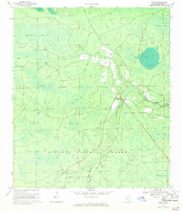
 1967 Moniac1968 Print · USGSThe Georgia-Florida state line meets the great swamp in the late sixties, where the river and rail lines converge. Trace local history at Moniac and Baxter, find the Moniac Cem, or follow the Dismantled Logging Tram through the marsh.
 - 1967 Map of Sargent, 1968 Print
 1967 Sargent1968 Print · USGSThe Georgia-Florida borderlands come alive in this late-sixties experimental survey, where the great southern swamps meet the rail line. Researchers can trace the Southern railroad through the Okefenokee Swamp past Sargent and Moorehead.
 - 1967 Map of Eddy, 1968 Print
 1967 Eddy1968 Print · USGSThe Florida-Georgia borderlands near the Okefenokee Swamp are captured in the late 1960s, showing a remote landscape of wetlands and rails. Trace the path of the Southern railroad past the Radio Lookout Tower and islands like Mitchell Island.
 - 1969 Map of Sanderson NW, 1971 Print
 1969 Sanderson NW1971 Print · USGSUpper Baker County in the late sixties remains a wilderness of vast wetlands and timber tracks within the Osceola National Forest. Outdoorsmen and researchers can trace the old routes of Sand Hill Road and find isolated landmarks like Negro Camp Island and Buck Island Lake.3 unique versions available
 - 1969 Map of Sanderson North, 1971 Print
 1969 Sanderson North1971 Print · USGSBaker County in the late 1960s was a landscape of dense national forest and quiet rail-side communities. Genealogists and historians can trace family locations near Sanderson, finding local landmarks like Cedar Creek Ch (Cem) and the Central Sch.2 unique versions available
 - 1969 Map of Big Gum Swamp, 1971 Print
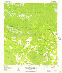
 1969 Big Gum Swamp1971 Print · USGSThe Florida-Georgia borderlands in the late sixties were defined by the deep woods of the Osceola National Forest. Researchers can trace the hydrology of the St Marys River headwaters and find forest locations like Seventeenmile Camp and Big Island.3 unique versions available
 - 1969 Map of Taylor, 1971 Print
 1969 Taylor1971 Print · USGSIn the late sixties, the northern reaches of Baker County were a mosaic of timberland and deep wetlands within the Osceola National Forest. Researchers can trace the community around Taylor, locate the Pleasant Grove Ch, and identify remote landmarks like the Lookout Tower and Huckleberry Island.3 unique versions available
 - 1970 Map of Manning, 1973 Print
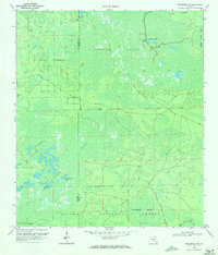
 1970 Manning1973 Print · USGSBaker and Union counties are shown here in the early 1970s, a landscape shaped by the Seaboard Coast Line and the Northeast Florida State Hospital. Genealogists can trace rural communities like Sapp, Manning, and Steckert alongside landmarks like Manntown Ch.
 - 1970 Map of Maxville, 1973 Print
 1970 Maxville1973 Print · USGSNorth Florida's timberlands and rail corridors are captured here in the early 1970s at the meeting of four counties. Genealogists and historians can trace the rural communities of Maxville and Hugh or locate old crossings at Turkey Creek and Bessent.2 unique versions available
 - 1972 Map of Macclenny NW, 1973 Print
 1972 Macclenny NW1973 Print · USGSThe Florida-Georgia borderland in the early 1970s reveals a world of wetland bays and quiet rural communities along the St Marys River. Genealogists and local historians can trace family locations near community hubs like Baxter Ch, Moniac Ch, and the Taylor Sch.2 unique versions available
 - 1972 Map of Macclenny West, 1973 Print
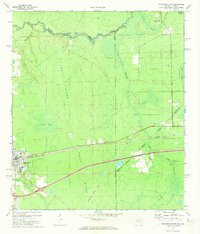
 1972 Macclenny West1973 Print · USGSBaker County at the start of the 1970s is shown here as a landscape of rail-side towns and river bends. Genealogists and historians can trace the foundations of Glen St Mary and Margaretta, and locate family burial sites at Woodlawn Cem or Turner Cem.3 unique versions available
 - 1972 Map of Macclenny East, 1973 Print
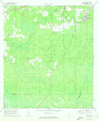
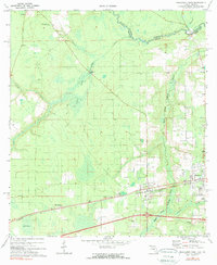
 1972 Macclenny East1973 Print · USGSThe Baker County seat and the Georgia state line meet in the early 1970s along the historic Trail Ridge. Trace the rail corridor of the Seaboard Coast Line through Macclenny and find local landmarks like Brandy Branch Ch and Mattox.
 - 1980 Map of Okefenokee Swamp, 1981 Print
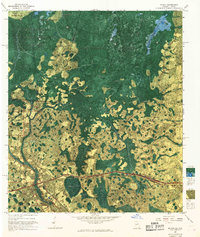
 1980 Okefenokee Swamp1981 Print · USGSThe Georgia-Florida borderlands come to life in the early 1980s, centered on the immense wilderness of the Okefenokee Swamp. Genealogists and historians can trace rail-stop settlements like Fargo and Fruitland or explore the interior geography of Billys Island and Trail Ridge.
Showing maps 1-25 of 113
Top cities of Baker County
Frequently asked questions
- What are the different types of historical maps available for Baker County?
- What is the oldest map of Baker County?
- Where can I purchase historical maps of Baker County for my home or office?
- Where can I download high-res historical maps of Baker County?
- Are there historical topographic maps available for Baker County?
- Is there historical aerial imagery available for Baker County?
- Where are historical maps of Baker County sourced from?