1990s Maps of Broward County, Florida
Explore 6 historic maps of Broward County from the 1990s. These maps offer a rare glimpse into what life looked like during the 1990s — showing old roads, neighborhoods, homes, and landmarks that have changed or disappeared over time.
Whether you're researching your family's past, planning a metal detecting trip, or studying how Broward County's landscape evolved across the 1990s, these high-resolution maps are a powerful tool for exploring the history of this region.
- Focus on a specific era: All maps on this page are from the 1990s, giving you a focused view of this time period.
- See what’s changed: Compare century-old streets, trails, and buildings to today's modern landscape using overlays and satellite layers.
- Research with precision: Use these maps for genealogy, historical research, land use analysis, or educational projects.
- View, download, or print: Maps are fully viewable online in high resolution, and can be downloaded or printed for your own records.
Start exploring Broward County's history through authentic maps from the 1990s. This is your window into the past.
Broward County, FL maps
(6)- 1994 Map of Fort Lauderdale South, 1999 Print
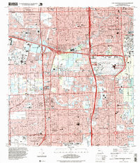 1994 Fort Lauderdale South1999 Print · USGSSouth Florida during the mid-nineties shows a landscape of rapid growth, defined by massive highway interchanges and coastal expansion. Trace family history and local development through detailed locations like Hollywood Indian Reservation, Nova University, and Old Pioneer Cem.
 - 1994 Map of North Miami, 2000 Print
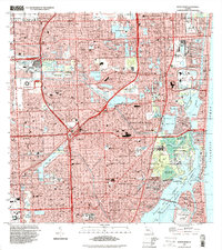 1994 North Miami2000 Print · USGSGreater Miami is captured here in the mid-nineties, showing a sprawling coastal landscape defined by luxury waterfront living and major sports venues. Researchers can trace the layout of Golden Beach and Ives Estates or locate landmarks like Joe Robbie Stadium and Aventura Mall.
 - 1994 Map of Pennsuco, 2000 Print
 1994 Pennsuco2000 Print · USGSFlorida's edge at the turn of the millennium shows the intersection of massive water management and suburban expansion. Trace the engineering of the Miami Canal and find local landmarks like the Opa-Locka West Airport and the Pennsuco Footbridge.
 - 1994 Map of Cooper City, 2000 Print
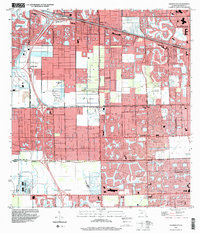 1994 Cooper City2000 Print · USGSBroward County’s suburban growth and canal engineering are on full display in the mid-nineties as Cooper City and Davie expand. Local researchers can locate landmark sites like Camp Seminole (BSA), the South Florida State Hospital, and Treetops Regional Park.
 - 1995 Map of Fort Lauderdale North, 1999 Print
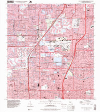 1995 Fort Lauderdale North1999 Print · USGSGreater Fort Lauderdale in the mid-nineties reveals a landscape of engineered waterways and suburban expansion. Researchers can trace the development of Sabal Palms Estates, the grounds of Lockhart Stadium, and the Queen of Heaven Cemetery.
 - 1995 Map of North Of Fortymile Bend, 1999 Print
 1995 North Of Fortymile Bend1999 Print · USGSThe Florida Everglades in the mid-1990s reveal a landscape defined by indigenous residency and conservation boundaries. Genealogists and historians can locate specific sites like Mart Law Seminole Village, Sam Willie Seminole Village, and Sam Franks Old Farm.
End of results
Showing maps 1-6 of 6
Top cities of Broward County
- Fort Lauderdale historical maps
- Pembroke Pines historical maps
- Hollywood historical maps
- Coral Springs historical maps
- Miramar historical maps
- Pompano Beach historical maps
See more
Frequently asked questions
- What are the different types of historical maps available for Broward County?
- What is the oldest map of Broward County?
- Where can I purchase historical maps of Broward County for my home or office?
- Where can I download high-res historical maps of Broward County?
- Are there historical topographic maps available for Broward County?
- Is there historical aerial imagery available for Broward County?
- Where are historical maps of Broward County sourced from?