Old Maps of Broward County, Florida for Genealogy
Trace your family roots with 216 historic maps of Broward County. These high-res maps reveal old neighborhoods, homesites, landmarks, and streets — helping you uncover where your ancestors lived and how the area evolved over time.
- Explore historic neighborhoods: Identify where your relatives may have lived in the 1800s or 1900s.
- Compare maps over time: Trace the changes in streets, buildings, and landmarks for multi-generational research.
- Perfect for genealogy & ancestry research: Used by family historians and researchers to map out lineage and migration.
These maps are an incredible resource for exploring your personal connection to Broward County's past.
Broward County, FL maps
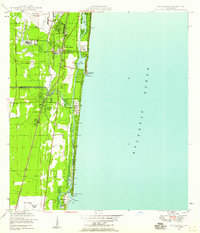
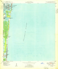
(216)- 1945 Map of Fort Lauderdale North
 1945 Fort Lauderdale North1945 Print · USGSBroward County at the end of the war shows a landscape of drainage canals and young coastal towns before the era of major suburban sprawl. Researchers can trace early infrastructure like the Fort Lauderdale Municipal Airport and the Farm Labor Supply Camp.
 - 1946 Map of West Dixie Bend, 1958 Print
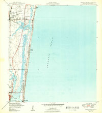
 1946 West Dixie Bend1958 Print · USGSCoastal Broward and Palm Beach counties are shown here just after the war, during an era of significant drainage and early development. Trace the early layout of Deerfield Beach, the course of the Hillsboro Canal, and the tracks of the Seaboard Air Line railroad.
 - 1946 Map of Boca Raton, 1958 Print
 1946 Boca Raton1958 Print · USGSThe South Florida coast at the end of the 1940s reveals a developing network of seaside towns and vital waterways. Genealogists and historians can trace the early footprints of Deerfield Beach and Hillsboro Beach, alongside the iconic Lighthouse and the Boca Raton Inlet.
 - 1947 Map of North Miami, 1959 Print
 1947 North Miami1959 Print · USGSCoastal Florida is shown in a period of significant post-war expansion between Hollywood and Miami Shores. Researchers can trace the layout of early communities and landmarks like the U S Naval Air Station, MacArthur Airport, and the Hollywood Kennel Club.
 - 1949 Map of Opalocka
 1949 Opalocka1949 Print · USGSNorth Miami-Dade was a hub of military aviation and early suburban expansion in the years following World War II. Researchers can trace the layout of the U S Naval Air Station and several regional airfields like Master Field and Municipal Field.2 unique versions available
 - 1949 Map of Fort Lauderdale North
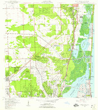
 1949 Fort Lauderdale North1949 Print · USGSCoastal Broward County is captured here just after the war as agriculture and aviation shaped the landscape. Genealogists and local historians can trace early neighborhood footprints and sites like the Farm Labor Supply Camp, Hammondville, and the Fort Lauderdale Municipal Airport.2 unique versions available
 - 1949 Map of West Dixie Bend
 1949 West Dixie Bend1949 Print · USGSCoastal Broward County and the edge of the Everglades are shown here in the late 1940s as infrastructure began to reshape the wetlands. Researchers can trace the early layout of Deerfield Beach and the inland settlement of West Dixie Bend near the Hillsboro Canal.2 unique versions available
 - 1949 Map of Port Everglades
 1949 Port Everglades1949 Print · USGSThe Broward County shoreline is captured in the late 1940s as the maritime infrastructure of Port Everglades began to define the coastal economy. Genealogists and historians can trace early neighborhood plats in Nurmi Isles and locate mid-century landmarks like the U S Naval Res and Dania City Park.2 unique versions available
 - 1949 Map of Fort Lauderdale South
 1949 Fort Lauderdale South1949 Print · USGSSoutheast Florida’s coastal corridor comes into focus at mid-century, as the cities of Fort Lauderdale and Hollywood begin to expand inland. Genealogists and historians can trace local landmarks like the Seminole Ch, the Riverside Military Academy, and the Florida East Coast rail line.2 unique versions available
 - 1949 Map of Pompano Beach
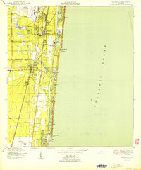
 1949 Pompano Beach1949 Print · USGSCoastal Broward County comes into focus in the late 1940s as development expands along the Florida East Coast rail line. Genealogists and researchers can trace the early layouts of Pompano Beach, Pinehurst Village, and the County Prison Camp.2 unique versions available
 - 1950 Map of Boca Raton
 1950 Boca Raton1950 Print · USGSSoutheast Florida’s coastline shows its mid-century character before the peak of modern development, centered on the growing resorts and transit hubs. Genealogists and historians can trace the early footprints of Boca Raton and Deerfield Beach, locating landmarks like the Lighthouse and the original Florida East Coast rail line.
 - 1950 Map of North Miami
 1950 North Miami1950 Print · USGSMid-century Miami-Dade County comes to life as coastal settlements like Bal Harbour and Surfside begin to take shape. Genealogists and historians can trace the foundations of Opa-locka and the sprawling U S Naval Air Station during this era of rapid growth.
 - 1956 Map of Miami, 1963 Print
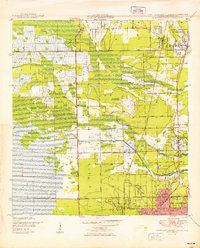
 1956 Miami1963 Print · USGSSouthern Florida experiences post-war expansion in the 1950s, even as the wilderness remains dominant across the southern peninsula. Genealogists and historians can trace suburban growth in Opa-locka and Perrine or locate remote sites like the Tamiami Ranger Station.5 unique versions available
 - 1956 Map of West Palm Beach, 1964 Print
 1956 West Palm Beach1964 Print · USGSSouth Florida during the mid-fifties exhibits a fascinating balance between expanding coastal cities and the vast interior wetlands. Researchers can trace the development of inland settlements like Immokalee and Okeelanta or locate vanished landmarks like Chosen and Buckingham Cem.2 unique versions available
 - 1957 Map of West Palm Beach
 1957 West Palm Beach1957 Print · USGSSouthern Florida in the mid-fifties reveals a landscape defined by massive drainage canals and the early expansion of the Gold Coast. Genealogists and historians can trace industrial outposts like the Sugar plant and Everglades Labor Center, or locate the Jupiter Auxiliary Air Force Base.
 - 1958 Map of West Palm Beach
 1958 West Palm Beach1958 Print · USGSSouth Florida in the late fifties was a land of transition between massive agricultural works and rapid coastal growth. Genealogists and historians can trace old canal networks, early rail lines like the Florida East Coast, and landmarks like the Moore Haven Lock or Jupiter Auxiliary Air Force Base.2 unique versions available
 - 1958 Map of Miami
 1958 Miami1958 Print · USGSSoutheast Florida in the late fifties reveals a coastal boom held in balance with the wild sawgrass and mangroves of Everglades National Park. Trace the paths of the Florida East Coast RR through Homestead or locate the U S Marine Corps Air Station during the height of the Cold War.
 - 1962 Map of Boca Raton, 1963 Print
 1962 Boca Raton1963 Print · USGSThe Florida coast near Boca Raton was undergoing a suburban boom in the early sixties, as seen through its new canal subdivisions and highway expansions. Trace the development of Lighthouse Point and find local landmarks like Boca Raton Cem and University Park.5 unique versions available
 - 1962 Map of Fort Lauderdale North, 1964 Print
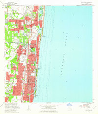
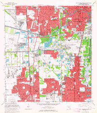
 1962 Fort Lauderdale North1964 Print · USGSCoastal Broward County is seen here during its mid-century suburban boom as subdivisions and schools rise from the landscape. Genealogists and historians can trace neighborhood growth in Wilton Manors or locate institutions like Provident Hospital and Queen of Heaven Cemetery.4 unique versions available
 - 1962 Map of Port Everglades, 1964 Print
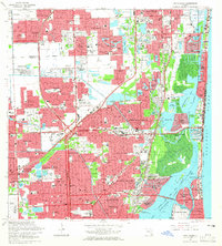
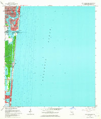 1962 Port Everglades1964 Print · USGSCoastal Broward County at the start of the sixties showcases a period of massive waterfront engineering and residential expansion. Trace the growth of Fort Lauderdale through its developed islands like Rio Vista Isles and the burgeoning industrial hub at Port Everglades.6 unique versions available
 - 1962 Map of West Dixie Bend, 1964 Print
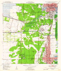
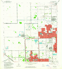
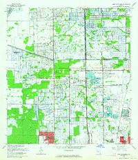 1962 West Dixie Bend1964 Print · USGSBroward County experiences a period of rapid development in the early sixties as the suburbs press against the Everglades. Researchers can trace early street grids and neighborhood boundaries for Margate, Sanders Park, and Carver Village alongside the Sunshine State Parkway.3 unique versions available
 - 1962 Map of Opa-locka, 1964 Print
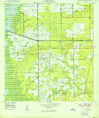
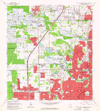
 1962 Opa-locka1964 Print · USGSNorth Dade County was undergoing a massive suburban transformation in the early sixties as new subdivisions began to border the Everglades. Researchers can trace early street layouts in Carol City and locate local landmarks like Biscayne College and the South Florida State Hospital.4 unique versions available
 - 1962 Map of Pompano Beach, 1964 Print
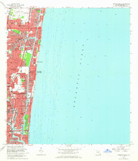 1962 Pompano Beach1964 Print · USGSThe Broward County shoreline was rapidly transforming in the early sixties as new canal-front neighborhoods expanded along the coast. Trace the development of Garden Isles and Sea Ranch Lakes, or locate mid-century landmarks like the Drive-in Theater and Holy Cross Hospital.5 unique versions available
 - 1962 Map of Fort Lauderdale South, 1964 Print
 1962 Fort Lauderdale South1964 Print · USGSCoastal Broward County is captured in the early sixties during a period of rapid westward expansion. Genealogists can trace family connections to suburban enclaves like Hacienda Village and schools such as St Thomas Aquinas High Sch.3 unique versions available
 - 1962 Map of North Miami, 1965 Print
 1962 North Miami1965 Print · USGSCoastal development and suburban growth characterize the North Miami area in the early sixties. Genealogists and local historians can trace family roots through numerous neighborhood schools and landmarks like Dade Memorial Park or the Biscayne Seaplane Base.3 unique versions available
Showing maps 1-25 of 216
Top cities of Broward County
- Fort Lauderdale historical maps
- Pembroke Pines historical maps
- Hollywood historical maps
- Coral Springs historical maps
- Miramar historical maps
- Pompano Beach historical maps
See more
Frequently asked questions
- What are the different types of historical maps available for Broward County?
- What is the oldest map of Broward County?
- Where can I purchase historical maps of Broward County for my home or office?
- Where can I download high-res historical maps of Broward County?
- Are there historical topographic maps available for Broward County?
- Is there historical aerial imagery available for Broward County?
- Where are historical maps of Broward County sourced from?