1970s Maps of Broward County, Florida
Explore 16 historic maps of Broward County from the 1970s. These maps offer a rare glimpse into what life looked like during the 1970s — showing old roads, neighborhoods, homes, and landmarks that have changed or disappeared over time.
Whether you're researching your family's past, planning a metal detecting trip, or studying how Broward County's landscape evolved across the 1970s, these high-resolution maps are a powerful tool for exploring the history of this region.
- Focus on a specific era: All maps on this page are from the 1970s, giving you a focused view of this time period.
- See what’s changed: Compare century-old streets, trails, and buildings to today's modern landscape using overlays and satellite layers.
- Research with precision: Use these maps for genealogy, historical research, land use analysis, or educational projects.
- View, download, or print: Maps are fully viewable online in high resolution, and can be downloaded or printed for your own records.
Start exploring Broward County's history through authentic maps from the 1970s. This is your window into the past.
Broward County, FL maps
(16)- 1973 Map of Custard Apple Hammock, 1976 Print
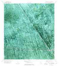
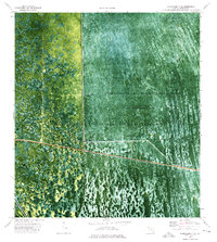
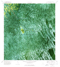
 1973 Custard Apple Hammock1976 Print · USGSThe Florida Everglades in the early seventies reveal a landscape of seasonal water flow and scattered tree islands along the Dade and Broward line. Trace the path of the Melaleuca Airboat Trail or locate the namesake Custard Apple Hammock in the Shark Valley Slough.2 unique versions available
 - 1973 Map of West Of Pennsuco, 1976 Print
 1973 West Of Pennsuco1976 Print · USGSThe Florida Everglades in the early 1970s are captured here as a landscape of sawgrass and water management infrastructure. Researchers can trace the path of an Airboat Trail and examine the engineering of the L-67A Levee and L-67C Levee.
 - 1973 Map of Everglades 4 NW, 1976 Print
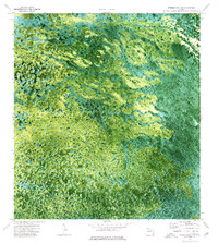
 1973 Everglades 4 NW1976 Print · USGSBroward County’s sawgrass and sloughs are captured in the early seventies, illustrating the managed water systems of the Everglades Wildlife Management Area. Trace the specialized routes of the day, from the Miami Canal to local paths like Weasel Trail and Misery Trail.2 unique versions available
 - 1973 Map of Everglades 4 NE, 1976 Print
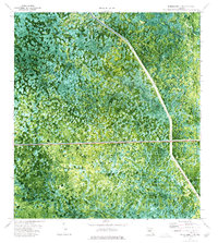
 1973 Everglades 4 NE1976 Print · USGSBroward County’s wild interior is documented in the 1970s, showcasing the intricate water management systems of the western Everglades. Researchers can trace specialized travel routes like the Airboat Trail and Weasel Trail near the Mud Canal.2 unique versions available
 - 1973 Map of Everglades 4 SE, 1976 Print
 1973 Everglades 4 SE1976 Print · USGSIn the early 1970s, the Broward County interior remained a landscape of managed wetlands and vital water arteries. Hydrologists and local historians can trace the paths of the Miami Canal and New River Canal past Gator Lake and remote airboat routes.2 unique versions available
 - 1973 Map of Fort Lauderdale 2 SW, 1976 Print
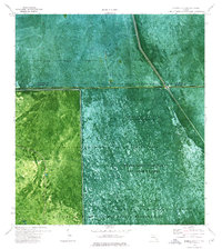
 1973 Fort Lauderdale 2 SW1976 Print · USGSThe Florida Everglades are captured in the early 1970s, revealing a landscape of managed wetlands and water conservation. Researchers can trace the path of the North New River Canal or follow specialized routes like the Airboat Trail and Weasel Trail.2 unique versions available
 - 1973 Map of Everglades 4 SW, 1976 Print
 1973 Everglades 4 SW1976 Print · USGSBroward County's interior wetlands are captured in the early seventies, showing a landscape defined by water and sawgrass. Trace the routes of the South Airboat Trail and Holiday Airboat Trail to the settlement at Jessie Willies.2 unique versions available
 - 1973 Map of Everglades 3 NE, 1976 Print
 1973 Everglades 3 NE1976 Print · USGSThe Miccosukee lands and the Everglades management areas appear in this early 1970s orthophoto survey as a complex web of canals and levees. Researchers can trace specialized wetland routes like the Weasel Airboat Trail and vital infrastructure such as Pumping Sta 3 and the Everglades Parkway.2 unique versions available
 - 1973 Map of North of Fortymile Bend, 1976 Print
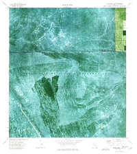
 1973 North of Fortymile Bend1976 Print · USGSThe Florida Everglades in the early seventies are seen here in detail through aerial photography and topographic mapping. Researchers can trace historic land use at Mari Law Seminole Village and Sam Franks Old Farm while observing the water management of Conservation Area No 3A.2 unique versions available
 - 1974 Map of Everglades 1 SW, 1976 Print
 1974 Everglades 1 SW1976 Print · USGSThe Florida Everglades in the mid-1970s reveal a landscape defined by water management and wetland navigation. Researchers can trace the path of the Miami Canal and numerous Airboat Trails crossing through Conservation Area No 3A.2 unique versions available
 - 1974 Map of Everglades 2 SW, 1976 Print
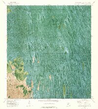
 1974 Everglades 2 SW1976 Print · USGSThe Florida Everglades meet the interior wetlands during the mid-seventies in this detailed orthophotomap of the Big Cypress Seminole Indian Reservation. Researchers can locate community landmarks like Ahfachkee Day Sch and the site of Browns Indian Trading Post (Ruins) amidst the strands.2 unique versions available
 - 1974 Map of Everglades 2 SE, 1976 Print
 1974 Everglades 2 SE1976 Print · USGSThe Florida Everglades and tribal lands are revealed in the mid-1970s through this aerial-base orthophotomap of the interior wetlands. You can trace the engineered landscape along Levee 28 and locate remote outposts like Matthews Airfield and Pump Station No 8.3 unique versions available
 - 1974 Map of Everglades 3 SW, 1976 Print
 1974 Everglades 3 SW1976 Print · USGSThe Florida Everglades interior is captured in high-resolution detail during the mid-1970s, showcasing the native landscape across the Collier Co border. Researchers can trace the precise boundaries of the Florida State Miccosukee Indian Reservation and study the natural distribution of tree islands.2 unique versions available
 - 1974 Map of Everglades 3 NW, 1976 Print
 1974 Everglades 3 NW1976 Print · USGSThe Florida Everglades in the mid-1970s reveal a landscape of vast wetlands and engineering efforts to manage them. Trace the boundaries of the Miccosukee Indian Reservation and locate remote landing strips near Doctors Prairie.3 unique versions available
 - 1974 Map of Everglades 1 SE, 1976 Print
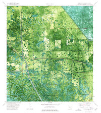
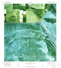 1974 Everglades 1 SE1976 Print · USGSThe Florida Everglades meet industrial water management in the 1970s at the junction of the Palm Beach and Broward county lines. Local historians can trace early settlements like Deem City and Terrytown or follow specialized routes like the Weasel Airboat Trail.2 unique versions available
 - 1974 Map of Everglades 3 SE, 1976 Print
 1974 Everglades 3 SE1976 Print · USGSThe Florida Everglades in the mid-1970s reveal a landscape defined by seasonal water and tribal lands. Researchers can trace the Reservation Boundary across the swamp, locating landmarks like Horseshoe Head and the winding Airboat Trail.2 unique versions available
End of results
Showing maps 1-16 of 16
Top cities of Broward County
- Fort Lauderdale historical maps
- Pembroke Pines historical maps
- Hollywood historical maps
- Coral Springs historical maps
- Miramar historical maps
- Pompano Beach historical maps
See more
Frequently asked questions
- What are the different types of historical maps available for Broward County?
- What is the oldest map of Broward County?
- Where can I purchase historical maps of Broward County for my home or office?
- Where can I download high-res historical maps of Broward County?
- Are there historical topographic maps available for Broward County?
- Is there historical aerial imagery available for Broward County?
- Where are historical maps of Broward County sourced from?