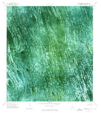
1973 Map of Everglades 4 SW
USGS Topo · Published 1976About this map
Conservation Area No 3A and the surrounding Everglades Wildlife Management Area dominate this orthophotomap, showing the intricate hydrology of Broward County in the early 1970s. The landscape is defined by the distinct northwest-to-southeast linear patterns of sawgrass ridges and sloughs, where water is impounded periodically. In a region largely devoid of dry-land infrastructure, the small settlement at Jessie Willies and the landform known as Melaleuca Head stand out as rare named landmarks amidst the wetlands. Transportation through this sodden environment is restricted to specialized routes such as the South Airboat Trail, Holiday Airboat Trail, and Melaleuca Airboat Trail, which provide the primary means of navigating the interior marsh. This survey documents the area before more modern drainage and management practices further altered these specific wilderness tracts.
Find a feature on this map
8 named features on this map. Tap any name to fly to it.
Don’t see what you’re looking for? This feature index may not catch every label — zoom into the map to look around manually.
Map Details
Editions of this 1973 Everglades 4 SW Map
2 editions found
Other maps of this area

1956 · Miami
USGS Topo · 1:250,000

1956 · West Palm Beach
USGS Topo · 1:250,000

1957 · West Palm Beach
USGS Topo · 1:250,000

1958 · West Palm Beach
USGS Topo · 1:250,000

1958 · Miami
USGS Topo · 1:250,000

1973 · Custard Apple Hammock
USGS Topo · 1:24,000

1973 · West Of Pennsuco
USGS Topo · 1:24,000

1973 · Everglades 4 NW
USGS Topo · 1:24,000

1973 · Everglades 4 NE
USGS Topo · 1:24,000

1973 · Everglades 4 SE
USGS Topo · 1:24,000