
1973 Map of Everglades 4 SE
USGS Topo · Published 1976About this map
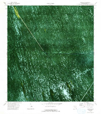
Everglades Wildlife Management Area dominates this early 1970s orthophotomap, showing the intricate hydrology and vegetation of Conservation Area No 3A. The landscape is defined by the rigid geometry of the Miami Canal and New River Canal intersecting the wetland, where water is impounded periodically to manage the ecosystem. A solitary Camp and a Gaging Sta appear as small outposts of human activity within the sawgrass and sloughs. Small water bodies like Gator Lake punctuate the green expanse, while specialized transport routes such as the Airboat South Trail and Holiday Trail reveal how the interior was navigated before modern encroachment. The photographic base of this survey captures the organic patterns of the hammock and marsh before significant late-century changes to the regional water management system.
Find a feature on this map
15 named features on this map. Tap any name to fly to it.
Don’t see what you’re looking for? This feature index may not catch every label — zoom into the map to look around manually.
Map Details
Editions of this 1973 Everglades 4 SE Map
2 editions found
Other maps of this area

1956 · Miami
USGS Topo · 1:250,000

1956 · West Palm Beach
USGS Topo · 1:250,000

1957 · West Palm Beach
USGS Topo · 1:250,000

1958 · West Palm Beach
USGS Topo · 1:250,000

1958 · Miami
USGS Topo · 1:250,000

1963 · Andytown
USGS Topo · 1:24,000

1963 · Pennsuco
USGS Topo · 1:24,000

1963 · Cooper City SW
USGS Topo · 1:24,000

1973 · Custard Apple Hammock
USGS Topo · 1:24,000

1973 · West Of Pennsuco
USGS Topo · 1:24,000