
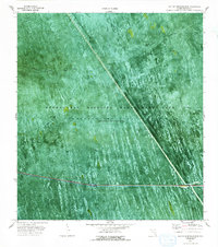
1973 Map of Everglades 4 NW
USGS Topo · Published 1976About this map
The Everglades Wildlife Management Area dominates this early 1970s orthophotomap, showing the intricate hydrology of Conservation Area No 3A where water is impounded periodically. The landscape is defined by the straight cut of the Miami Canal and its associated benchmarks like BM 15, which contrast with the organic, shifting patterns of the wetlands. A specialized network of transit is visible through numerous Airboat Trails and distinctive paths such as Weasel Trail and Misery Trail, reflecting the unique challenges of traversing the marsh. Along the southern edge, the Everglades Parkway (Toll Road) provides a modern corridor through the swamp, accompanied by infrastructure like a Gaging Sta, a Boat Ramp, and a Pipeline. This map offers a photographic record of the region's managed water levels and specialized transport routes before later restoration efforts.
Find a feature on this map
21 named features on this map. Tap any name to fly to it.
Don’t see what you’re looking for? This feature index may not catch every label — zoom into the map to look around manually.
Map Details
Editions of this 1973 Everglades 4 NW Map
2 editions found
Other maps of this area

1956 · West Palm Beach
USGS Topo · 1:250,000

1957 · West Palm Beach
USGS Topo · 1:250,000

1958 · West Palm Beach
USGS Topo · 1:250,000

1973 · Everglades 4 NE
USGS Topo · 1:24,000

1973 · Everglades 4 SE
USGS Topo · 1:24,000
1973 · Everglades 4 SW
USGS Topo · 1:24,000

1973 · Everglades 3 NE
USGS Topo · 1:24,000

1974 · Everglades 1 SW
USGS Topo · 1:24,000

1974 · Everglades 2 SE
USGS Topo · 1:24,000

1974 · Everglades 1 SE
USGS Topo · 1:24,000