
1973 Map of Everglades 4 NE
USGS Topo · Published 1976About this map
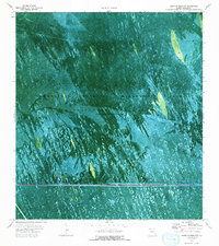
Everglades Wildlife Management Area Conservation Area No 3 dominates this 1970s orthophotomap, revealing the complex hydrology of the western Everglades in Broward Co. The landscape is a mosaic of wet prairie and sawgrass, where water impounded periodically in this area is managed through a network of infrastructure including the Mud Canal and a prominent Pipeline. Human movement through this environment is strictly specialized, evidenced by the intricate system of Airboat Trail, Weasel Trail, and the Airboat North Trail that cut through the vegetation. Along the southern edge, the Toll Road provides the only high-speed corridor, punctuated by various benchmarks like BM 24 and BM 20. This survey offers a precise record of water management and backcountry access before modern development further altered the flow and character of the northern glades.
Find a feature on this map
14 named features on this map. Tap any name to fly to it.
Don’t see what you’re looking for? This feature index may not catch every label — zoom into the map to look around manually.
Map Details
Editions of this 1973 Everglades 4 NE Map
2 editions found
Other maps of this area

1956 · West Palm Beach
USGS Topo · 1:250,000

1957 · West Palm Beach
USGS Topo · 1:250,000

1958 · West Palm Beach
USGS Topo · 1:250,000

1963 · Andytown
USGS Topo · 1:24,000

1963 · Cooper City SW
USGS Topo · 1:24,000

1973 · Everglades 4 NW
USGS Topo · 1:24,000

1973 · Everglades 4 SE
USGS Topo · 1:24,000

1973 · Fort Lauderdale 2 SW
USGS Topo · 1:24,000

1973 · Everglades 4 SW
USGS Topo · 1:24,000

1974 · Everglades 1 SW
USGS Topo · 1:24,000