
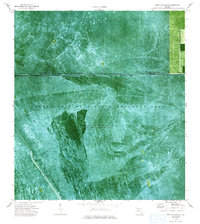
1974 Map of Everglades 1 SW
USGS Topo · Published 1976About this map
Everglades Wildlife Management Area dominates this mid-1970s orthophotomap, showing the complex water management systems of southern Florida. The map detail highlights the Miami Canal and the critical infrastructure of Levee 6 and Levee 5 which delineate the boundary between Palm Beach and Broward counties. This orthophoto provides a photographic perspective of the wetland terrain, revealing the network of Airboat Trails cutting through the vegetation. Central to the landscape is Conservation Area No 3A, where water is impounded periodically. The imagery captures the transition between managed water conservation zones and the more structured patterns appearing along the northern quadrangle border.
Find a feature on this map
7 named features on this map. Tap any name to fly to it.
Don’t see what you’re looking for? This feature index may not catch every label — zoom into the map to look around manually.
Map Details
Editions of this 1974 Everglades 1 SW Map
2 editions found
Other maps of this area

1956 · West Palm Beach
USGS Topo · 1:250,000

1957 · West Palm Beach
USGS Topo · 1:250,000

1958 · West Palm Beach
USGS Topo · 1:250,000

1973 · Everglades 4 NW
USGS Topo · 1:24,000

1973 · Everglades 4 NE
USGS Topo · 1:24,000

1973 · Everglades 3 NE
USGS Topo · 1:24,000

1974 · Everglades 2 SE
USGS Topo · 1:24,000

1974 · Everglades 1 NW
USGS Topo · 1:24,000

1974 · Everglades 1 SE
USGS Topo · 1:24,000
1974 · Everglades 1 NE
USGS Topo · 1:24,000