
1974 Map of Everglades 1 NW
USGS Topo · Published 1976About this map
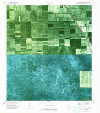
North New River Canal cuts a sharp diagonal through this 1970s orthophotomap, illustrating the engineered management of the Florida Everglades. The landscape is a study in agricultural transformation, divided by a rigid grid of section lines and water management infrastructure. Parallel to the canal, Levee 19 and Levee 18 define the boundary between different land use zones, separating cultivated fields from the expansive wetland areas of Palm Beach County. Several Pumps are positioned along the primary waterway, essential for maintaining the precarious balance of drainage required for this reclaimed environment. This specific survey, based on 1971 aerial photography, documents the industrial scale of the sugar and vegetable farming operations that reshaped the northern Glades during this era.
Find a feature on this map
8 named features on this map. Tap any name to fly to it.
Don’t see what you’re looking for? This feature index may not catch every label — zoom into the map to look around manually.
Map Details
Editions of this 1974 Everglades 1 NW Map
2 editions found
Other maps of this area

1956 · West Palm Beach
USGS Topo · 1:250,000

1957 · West Palm Beach
USGS Topo · 1:250,000

1958 · West Palm Beach
USGS Topo · 1:250,000

1970 · Lake Harbor SE
USGS Topo · 1:24,000

1970 · Okeelanta
USGS Topo · 1:24,000

1970 · Shawano
USGS Topo · 1:24,000

1974 · Everglades 1 SW
USGS Topo · 1:24,000

1974 · Everglades 2 SE
USGS Topo · 1:24,000

1974 · Everglades 1 SE
USGS Topo · 1:24,000
1974 · Everglades 1 NE
USGS Topo · 1:24,000