
1970 Map of Shawano
USGS Topo · Published 1976About this map
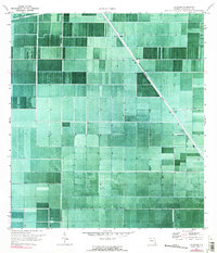
Shawano and the surrounding agricultural landscape of Palm Beach County are captured here through a detailed orthophotomosaic, blending aerial photography with traditional topographic data. The terrain is defined by a rigorous grid of fields and water management infrastructure, most notably the Hillsboro Canal which cuts diagonally across the southern Florida mucklands. This 1970 snapshot reveals the industrial scale of the region's drainage system, featuring numerous Pump and Pumps stations required to maintain the water levels for large-scale farming. Along the northern edge, the Bolles Canal serves as another primary artery in this hydraulic network. The map illustrates the stark geometry of the Everglades' transformation into a productive agricultural engine, where the straight lines of private surveys and massive canals replaced natural wetlands.
Find a feature on this map
5 named features on this map. Tap any name to fly to it.
Don’t see what you’re looking for? This feature index may not catch every label — zoom into the map to look around manually.
Map Details
Editions of this 1970 Shawano Map
2 editions found
Other maps of this area

1956 · West Palm Beach
USGS Topo · 1:250,000

1957 · West Palm Beach
USGS Topo · 1:250,000

1958 · West Palm Beach
USGS Topo · 1:250,000

1970 · Belle Glade
USGS Topo · 1:24,000

1970 · Okeelanta
USGS Topo · 1:24,000

1970 · Loxahatchee NW
USGS Topo · 1:24,000

1970 · Loxahatchee SW
USGS Topo · 1:24,000

1970 · Sixmile Bend
USGS Topo · 1:24,000

1974 · Everglades 1 NW
USGS Topo · 1:24,000
1974 · Fort Lauderdale 2 NW
USGS Topo · 1:24,000