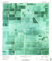
1970 Map of Shawano
USGS Topo · Published 1990About this map
Shawano and Bolles anchor this orthophotomap of the Florida Everglades, which captures the region's intensive transformation into a structured agricultural landscape during the 1970s. The aerial imagery reveals a massive grid of canals and fields, a stark contrast to the natural wetlands that once dominated Palm Beach County. The diagonal path of the Hillsboro Canal cuts through the surveyed sections, serving as a primary artery for water management in the district. The prevalence of numerous Pump stations along the drainage ditches illustrates the engineering required to maintain these muck lands for cultivation. This document provides a rare visual record of land use patterns at the height of the area's agricultural expansion, showing the precise layout of the drainage infrastructure and property divisions before later conservation efforts began to re-evaluate the hydrology of the northern Glades.
Find a feature on this map
7 named features on this map. Tap any name to fly to it.
Don’t see what you’re looking for? This feature index may not catch every label — zoom into the map to look around manually.
Map Details
Editions of this 1970 Shawano Map
2 editions found
Other maps of this area

1956 · West Palm Beach
USGS Topo · 1:250,000

1957 · West Palm Beach
USGS Topo · 1:250,000

1958 · West Palm Beach
USGS Topo · 1:250,000

1970 · Belle Glade
USGS Topo · 1:24,000

1970 · Okeelanta
USGS Topo · 1:24,000

1970 · Loxahatchee NW
USGS Topo · 1:24,000

1970 · Loxahatchee SW
USGS Topo · 1:24,000

1970 · Shawano
USGS Topo · 1:24,000

1970 · Sixmile Bend
USGS Topo · 1:24,000

1974 · Everglades 1 NW
USGS Topo · 1:24,000