1940s Maps of Fort Lauderdale, Florida
Explore 5 historic maps of Fort Lauderdale from the 1940s. These maps offer a rare glimpse into what life looked like during the 1940s — showing old roads, neighborhoods, homes, and landmarks that have changed or disappeared over time.
Whether you're researching your family's past, planning a metal detecting trip, or studying how Fort Lauderdale's landscape evolved across the 1940s, these high-resolution maps are a powerful tool for exploring the history of this region.
- Focus on a specific era: All maps on this page are from the 1940s, giving you a focused view of this time period.
- See what’s changed: Compare century-old streets, trails, and buildings to today's modern landscape using overlays and satellite layers.
- Research with precision: Use these maps for genealogy, historical research, land use analysis, or educational projects.
- View, download, or print: Maps are fully viewable online in high resolution, and can be downloaded or printed for your own records.
Start exploring Fort Lauderdale's history through authentic maps from the 1940s. This is your window into the past.
Fort Lauderdale, FL maps
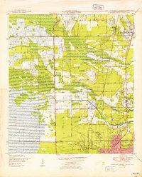
(5)- 1945 Map of Fort Lauderdale North
 1945 Fort Lauderdale North1945 Print · USGSBroward County at the end of the war shows a landscape of drainage canals and young coastal towns before the era of major suburban sprawl. Researchers can trace early infrastructure like the Fort Lauderdale Municipal Airport and the Farm Labor Supply Camp.
 - 1949 Map of Fort Lauderdale North
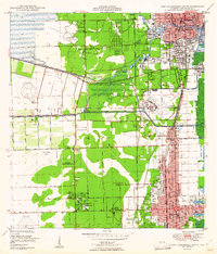
 1949 Fort Lauderdale North1949 Print · USGSCoastal Broward County is captured here just after the war as agriculture and aviation shaped the landscape. Genealogists and local historians can trace early neighborhood footprints and sites like the Farm Labor Supply Camp, Hammondville, and the Fort Lauderdale Municipal Airport.2 unique versions available
 - 1949 Map of Port Everglades
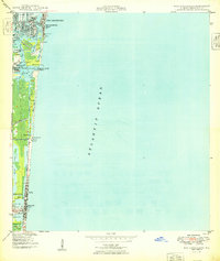 1949 Port Everglades1949 Print · USGSThe Broward County shoreline is captured in the late 1940s as the maritime infrastructure of Port Everglades began to define the coastal economy. Genealogists and historians can trace early neighborhood plats in Nurmi Isles and locate mid-century landmarks like the U S Naval Res and Dania City Park.2 unique versions available
 - 1949 Map of Fort Lauderdale South
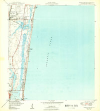
 1949 Fort Lauderdale South1949 Print · USGSSoutheast Florida’s coastal corridor comes into focus at mid-century, as the cities of Fort Lauderdale and Hollywood begin to expand inland. Genealogists and historians can trace local landmarks like the Seminole Ch, the Riverside Military Academy, and the Florida East Coast rail line.2 unique versions available
 - 1949 Map of Pompano Beach
 1949 Pompano Beach1949 Print · USGSCoastal Broward County comes into focus in the late 1940s as development expands along the Florida East Coast rail line. Genealogists and researchers can trace the early layouts of Pompano Beach, Pinehurst Village, and the County Prison Camp.2 unique versions available
End of results
Showing maps 1-5 of 5
Top cities near Fort Lauderdale
- Pembroke Pines historical maps
- Hollywood historical maps
- Coral Springs historical maps
- Miramar historical maps
- Pompano Beach historical maps
- Miami Gardens historical maps
See more
Top neighborhoods of Fort Lauderdale
- Rock Island historical maps
- Coral Hills historical maps
- Coral Ridge historical maps
- Coral Ridge Isles historical maps
- Harbor Beach historical maps
- North Bal Harbor historical maps
See more
Frequently asked questions
- What are the different types of historical maps available for Fort Lauderdale?
- What is the oldest map of Fort Lauderdale?
- Where can I purchase historical maps of Fort Lauderdale for my home or office?
- Where can I download high-res historical maps of Fort Lauderdale?
- Are there historical topographic maps available for Fort Lauderdale?
- Is there historical aerial imagery available for Fort Lauderdale?
- Where are historical maps of Fort Lauderdale sourced from?