1960s Maps of Fort Lauderdale, Florida
Explore 4 historic maps of Fort Lauderdale from the 1960s. These maps offer a rare glimpse into what life looked like during the 1960s — showing old roads, neighborhoods, homes, and landmarks that have changed or disappeared over time.
Whether you're researching your family's past, planning a metal detecting trip, or studying how Fort Lauderdale's landscape evolved across the 1960s, these high-resolution maps are a powerful tool for exploring the history of this region.
- Focus on a specific era: All maps on this page are from the 1960s, giving you a focused view of this time period.
- See what’s changed: Compare century-old streets, trails, and buildings to today's modern landscape using overlays and satellite layers.
- Research with precision: Use these maps for genealogy, historical research, land use analysis, or educational projects.
- View, download, or print: Maps are fully viewable online in high resolution, and can be downloaded or printed for your own records.
Start exploring Fort Lauderdale's history through authentic maps from the 1960s. This is your window into the past.
Fort Lauderdale, FL maps
(4)- 1962 Map of Fort Lauderdale North, 1964 Print
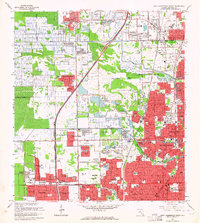 1962 Fort Lauderdale North1964 Print · USGSCoastal Broward County is seen here during its mid-century suburban boom as subdivisions and schools rise from the landscape. Genealogists and historians can trace neighborhood growth in Wilton Manors or locate institutions like Provident Hospital and Queen of Heaven Cemetery.4 unique versions available
 - 1962 Map of Port Everglades, 1964 Print
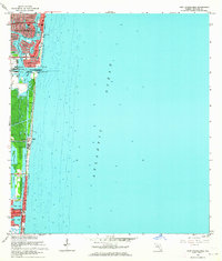 1962 Port Everglades1964 Print · USGSCoastal Broward County at the start of the sixties showcases a period of massive waterfront engineering and residential expansion. Trace the growth of Fort Lauderdale through its developed islands like Rio Vista Isles and the burgeoning industrial hub at Port Everglades.6 unique versions available
 - 1962 Map of Pompano Beach, 1964 Print
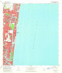 1962 Pompano Beach1964 Print · USGSThe Broward County shoreline was rapidly transforming in the early sixties as new canal-front neighborhoods expanded along the coast. Trace the development of Garden Isles and Sea Ranch Lakes, or locate mid-century landmarks like the Drive-in Theater and Holy Cross Hospital.5 unique versions available
 - 1962 Map of Fort Lauderdale South, 1964 Print
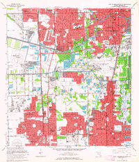 1962 Fort Lauderdale South1964 Print · USGSCoastal Broward County is captured in the early sixties during a period of rapid westward expansion. Genealogists can trace family connections to suburban enclaves like Hacienda Village and schools such as St Thomas Aquinas High Sch.3 unique versions available
End of results
Showing maps 1-4 of 4
Top cities near Fort Lauderdale
- Pembroke Pines historical maps
- Hollywood historical maps
- Coral Springs historical maps
- Miramar historical maps
- Pompano Beach historical maps
- Miami Gardens historical maps
See more
Top neighborhoods of Fort Lauderdale
- Rock Island historical maps
- Coral Hills historical maps
- Coral Ridge historical maps
- Coral Ridge Isles historical maps
- Harbor Beach historical maps
- North Bal Harbor historical maps
See more
Frequently asked questions
- What are the different types of historical maps available for Fort Lauderdale?
- What is the oldest map of Fort Lauderdale?
- Where can I purchase historical maps of Fort Lauderdale for my home or office?
- Where can I download high-res historical maps of Fort Lauderdale?
- Are there historical topographic maps available for Fort Lauderdale?
- Is there historical aerial imagery available for Fort Lauderdale?
- Where are historical maps of Fort Lauderdale sourced from?