1950s Maps of Calhoun County, Florida
Explore 8 historic maps of Calhoun County from the 1950s. These maps offer a rare glimpse into what life looked like during the 1950s — showing old roads, neighborhoods, homes, and landmarks that have changed or disappeared over time.
Whether you're researching your family's past, planning a metal detecting trip, or studying how Calhoun County's landscape evolved across the 1950s, these high-resolution maps are a powerful tool for exploring the history of this region.
- Focus on a specific era: All maps on this page are from the 1950s, giving you a focused view of this time period.
- See what’s changed: Compare century-old streets, trails, and buildings to today's modern landscape using overlays and satellite layers.
- Research with precision: Use these maps for genealogy, historical research, land use analysis, or educational projects.
- View, download, or print: Maps are fully viewable online in high resolution, and can be downloaded or printed for your own records.
Start exploring Calhoun County's history through authentic maps from the 1950s. This is your window into the past.
Calhoun County, FL maps
(8)- 1952 Map of Alford SE, 1953 Print
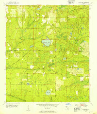 1952 Alford SE1953 Print · USGSThe Florida Panhandle's rural interior comes into focus here in the early fifties, where the Econfina River meets a landscape of ponds and creeks. Genealogists and local historians can trace family locations near Camps Head Ch and Pippen Cem.
 - 1952 Map of Altha West, 1953 Print
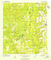 1952 Altha West1953 Print · USGSThe Chipola River valley and the town of Altha are captured here in the early fifties, documenting a landscape of rural schoolhouses and family cemeteries. Genealogists can trace sites like Old Shiloh Cem, Alliance Sch, and the Marianna and Blountstown rail line.
 - 1952 Map of Compass Lake, 1953 Print
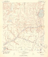 1952 Compass Lake1953 Print · USGSThe Florida Panhandle at mid-century reveals a landscape of lakeside settlements and growing infrastructure at the junction of three counties. Genealogists can trace family landmarks like Sandy Mount Ch, the settlement at Betts, and the Atlanta and St Andrews Bay rail line.3 unique versions available
 - 1952 Map of Altha East, 1953 Print
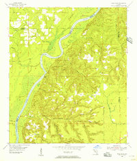
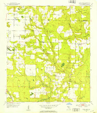 1952 Altha East1953 Print · USGSCalhoun and Jackson counties appear in the early 1950s, showing the rural communities of the Florida Panhandle before modern development. Genealogists can trace family landmarks like Henderson Mill, Barton Cem, and several country churches including Sunny Hill Ch.
 - 1954 Map of Tallahassee, 1967 Print
 1954 Tallahassee1967 Print · USGSThe Florida Panhandle and South Georgia are captured here during a period of mid-century growth and military expansion. Researchers can trace the development of Panama City, the footprint of Tyndall Air Force Base, and the rail lines of the Atlantic Coast Line.4 unique versions available
 - 1955 Map of Rock Bluff, 1956 Print
 1955 Rock Bluff1956 Print · USGSThe Florida Panhandle river country is captured here in the mid-fifties, centered on the winding Apalachicola River. Genealogists and historians can trace rural lifeways through landmarks like Rock Bluff, St Stephens Ch, and the high ridges of Torreya State Park.2 unique versions available
 - 1956 Map of North Of Allanton, 1957 Print
 1956 North Of Allanton1957 Print · USGSThe Florida Panhandle's wetland interior is captured here in the mid-fifties, showing a landscape defined by tidewater bayous and extensive swamps. Researchers can locate the Kent Cem, the Majette Lookout Tower, and small industrial Sandpits along the edges of Cooks Bayou.
 - 1959 Map of Tallahassee
 1959 Tallahassee1959 Print · USGSFlorida's Panhandle and the Big Bend region appear here in the mid-fifties, showing a landscape defined by its great river systems and developing coast. Trace the early layout of Panama City, the expansive Apalachicola National Forest, and the coastal St Marks Lighthouse.
End of results
Showing maps 1-8 of 8
Top cities of Calhoun County
Frequently asked questions
- What are the different types of historical maps available for Calhoun County?
- What is the oldest map of Calhoun County?
- Where can I purchase historical maps of Calhoun County for my home or office?
- Where can I download high-res historical maps of Calhoun County?
- Are there historical topographic maps available for Calhoun County?
- Is there historical aerial imagery available for Calhoun County?
- Where are historical maps of Calhoun County sourced from?