1980s Maps of Calhoun County, Florida
Explore 13 historic maps of Calhoun County from the 1980s. These maps offer a rare glimpse into what life looked like during the 1980s — showing old roads, neighborhoods, homes, and landmarks that have changed or disappeared over time.
Whether you're researching your family's past, planning a metal detecting trip, or studying how Calhoun County's landscape evolved across the 1980s, these high-resolution maps are a powerful tool for exploring the history of this region.
- Focus on a specific era: All maps on this page are from the 1980s, giving you a focused view of this time period.
- See what’s changed: Compare century-old streets, trails, and buildings to today's modern landscape using overlays and satellite layers.
- Research with precision: Use these maps for genealogy, historical research, land use analysis, or educational projects.
- View, download, or print: Maps are fully viewable online in high resolution, and can be downloaded or printed for your own records.
Start exploring Calhoun County's history through authentic maps from the 1980s. This is your window into the past.
Calhoun County, FL maps
(13)- 1981 Map of Panama City
 1981 Panama City1981 Print · USGSPanama City and the Florida Panhandle coast are captured here in the early eighties, showing the region's balance of military installations and maritime industry. Researchers can trace the Atlanta and St Andrews Bay RR or locate coastal sites like Tyndall Air Force Base and Dead Lake.2 unique versions available
 - 1982 Map of Compass Lake
 1982 Compass Lake1982 Print · USGSThe Florida Panhandle's lake country is captured here in the early eighties as the borders of four counties converge. Genealogists and local historians can locate rural landmarks like Sandy Mountain Ch, the small community of Betts, and the rail line of the Atlanta and Saint Andrews Bay Railway.
 - 1982 Map of Altha East
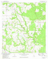 1982 Altha East1982 Print · USGSThe rural border of Jackson and Calhoun counties is captured here in the early 1980s as a landscape of timber and wetlands. Local historians can trace the foundations of Alliance and Macedonia or locate family sites like Barton Cem and Henderson Mill.
 - 1982 Map of Fountain, 1983 Print
 1982 Fountain1983 Print · USGSThe Florida Panhandle in the early eighties shows a landscape of timberlands and creek systems defined by the Atlanta and Saint Andrews Bay rail line. Trace local landmarks from Fountain down to Youngstown, including the Lookout Tower and Mitchell Hill.
 - 1982 Map of Altha West, 1983 Print
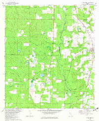 1982 Altha West1983 Print · USGSNorth Florida’s riverine landscape is captured here in the early eighties, centered on the Chipola River and the rural town of Altha. Local researchers can trace family landmarks like Ritchards Cem and Page Ch, or follow the path of the Old Railroad Grade.
 - 1982 Map of Youngstown, 1983 Print
 1982 Youngstown1983 Print · USGSThe Florida Panhandle's piney lowlands and wetlands are captured in the early eighties as the Atlanta and Saint Andrews Bay Railway connects rural outposts. Genealogists and local historians can trace the foundations of Youngstown, locate the Bear Creek Ch, and explore the wetlands around Crash Island.
 - 1982 Map of Alford SE, 1983 Print
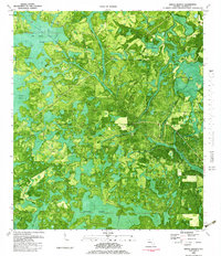
 1982 Alford SE1983 Print · USGSThe Florida Panhandle near the Jackson and Calhoun county line is shown here in the early eighties as residential growth began to meet rural tradition. Genealogists and local historians can locate Melvin, the Camps Head Ch, and family landmarks like Pippin Cem.
 - 1982 Map of North Of Allanton, 1983 Print
 1982 North Of Allanton1983 Print · USGSThe Florida Panhandle's wetland interior is captured in detail in the early 1980s as suburban growth reached the edge of the swamps. Genealogists and local researchers can locate Kent Cem, the Molette Lookout Tower, and the early footprints of East Callaway.
 - 1982 Map of Rock Bluff, 1983 Print
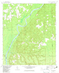 1982 Rock Bluff1983 Print · USGSThe Apalachicola River bluffs of Liberty County are captured here in the early eighties, centered on the diverse terrain of Torreya State Park. Researchers can trace old river access points like Hickory Landing and Porters Landing alongside several local churches and burial sites.
 - 1982 Map of Juniper Creek, 1983 Print
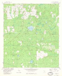
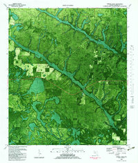 1982 Juniper Creek1983 Print · USGSCalhoun County's timberlands and river systems are captured in detail in the early eighties as they appeared from above. Genealogists and researchers can trace land use patterns through the Chipola Experimental Forest and locate features like the Sandpit and Big Bear Bay.
 - 1982 Map of Tenmile Swamp, 1983 Print
 1982 Tenmile Swamp1983 Print · USGSThe Florida Panhandle wetlands of the early eighties are seen here through a mix of aerial photography and topography. Researchers can trace family sites at Kemp Cem or navigate the water routes of Stone Mill Creek and the Willie Goodman Cutoff.
 - 1982 Map of Broad Branch, 1983 Print
 1982 Broad Branch1983 Print · USGSCalhoun County's dense wetlands and rural outposts are seen here in the early 1980s, revealing the intricate water systems of the Florida Panhandle. Researchers can trace the Old Railroad Grade and locate old settlements like Broad Branch and Johntown.
 - 1988 Map of Tallahassee
 1988 Tallahassee1988 Print · USGSThe Florida Panhandle and South Georgia are captured here in the late eighties, showing the expansion of the regional highway network and coastal growth. Genealogists and historians can trace rail lines like the Seaboard System Railroad or locate family roots in Blountstown, Graceville, or Crawfordville.2 unique versions available
End of results
Showing maps 1-13 of 13
Top cities of Calhoun County
Frequently asked questions
- What are the different types of historical maps available for Calhoun County?
- What is the oldest map of Calhoun County?
- Where can I purchase historical maps of Calhoun County for my home or office?
- Where can I download high-res historical maps of Calhoun County?
- Are there historical topographic maps available for Calhoun County?
- Is there historical aerial imagery available for Calhoun County?
- Where are historical maps of Calhoun County sourced from?