1980s Maps of Charlotte County, Florida
Explore 6 historic maps of Charlotte County from the 1980s. These maps offer a rare glimpse into what life looked like during the 1980s — showing old roads, neighborhoods, homes, and landmarks that have changed or disappeared over time.
Whether you're researching your family's past, planning a metal detecting trip, or studying how Charlotte County's landscape evolved across the 1980s, these high-resolution maps are a powerful tool for exploring the history of this region.
- Focus on a specific era: All maps on this page are from the 1980s, giving you a focused view of this time period.
- See what’s changed: Compare century-old streets, trails, and buildings to today's modern landscape using overlays and satellite layers.
- Research with precision: Use these maps for genealogy, historical research, land use analysis, or educational projects.
- View, download, or print: Maps are fully viewable online in high resolution, and can be downloaded or printed for your own records.
Start exploring Charlotte County's history through authentic maps from the 1980s. This is your window into the past.
Charlotte County, FL maps
(6)- 1981 Map of Fort Myers
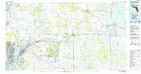
 1981 Fort Myers1981 Print · USGSSouthwest Florida experienced a transformative era of growth during the early eighties as coastal cities pushed inland toward the Everglades. Trace the expansion of Lehigh Acres and Cape Coral or locate rural landmarks like Palmdale and the Brighton Indian Reservation.
 - 1981 Map of Charlotte Harbor, 1983 Print
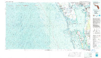 1981 Charlotte Harbor1983 Print · USGSCoastal Florida is captured in a period of significant growth during the early eighties, balancing new residential developments with vast protected preserves. Trace the expansion of Port Charlotte and Cape Coral alongside the Seaboard Coast Line and Cayo Costa State Preserve.
 - 1985 Map of Fort Myers, 1986 Print
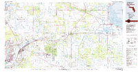
 1985 Fort Myers1986 Print · USGSSouthwest Florida during the mid-eighties shows a region of transition, where the riverfront growth of Fort Myers meets the inland marshes of the Everglades. Genealogists and historians can trace suburban expansion in Lehigh Acres or locate the old canal-side hubs of La Belle and Moore Haven.
 - 1987 Map of West Palm Beach, 1988 Print
 1987 West Palm Beach1988 Print · USGSSouth Florida is captured in the mid-1980s, showcasing the intricate balance between rapid coastal growth and the vast interior wetlands. Researchers can trace the drainage canals of The Everglades or locate the boundaries of the Big Cypress Seminole Indian Reservation and Loxahatchee National Wildlife Refuge.2 unique versions available
 - 1988 Map of Fort Pierce
 1988 Fort Pierce1988 Print · USGSThe Atlantic coast and Florida’s interior lakelands are captured in the late eighties, just as the Treasure Coast was experiencing rapid development. Genealogists and historians can trace the rail lines of the Florida East Coast and explore the bounds of the Brighton Indian Reservation.
 - 1988 Map of St Petersburg
 1988 St Petersburg1988 Print · USGSThe Florida Gulf Coast reached a peak of late-twentieth-century development as seen in this late-1980s look at the growing corridor from St Petersburg to Port Charlotte. Researchers can trace the expansion of coastal infrastructure, including MacDill Air Force Base, the Seaboard System RR, and regional parks like Fort De Soto Park.
End of results
Showing maps 1-6 of 6
Top cities of Charlotte County
- Port Charlotte historical maps
- Punta Gorda historical maps
- Rotonda historical maps
- Charlotte Harbor historical maps
- Cleveland historical maps
- Charlotte Park historical maps
See more
Frequently asked questions
- What are the different types of historical maps available for Charlotte County?
- What is the oldest map of Charlotte County?
- Where can I purchase historical maps of Charlotte County for my home or office?
- Where can I download high-res historical maps of Charlotte County?
- Are there historical topographic maps available for Charlotte County?
- Is there historical aerial imagery available for Charlotte County?
- Where are historical maps of Charlotte County sourced from?