Old Maps of Charlotte County, Florida for Academic Research
Study the evolution of Charlotte County with 157 high-resolution historic maps. Whether you're teaching, researching, or modeling changes in land use, these maps provide essential visual documentation of urban, environmental, and geographic change.
- Analyze long-term change: Track patterns in development, transportation, and natural features.
- Ideal for environmental or urban studies: Support academic projects with primary historical map data.
- Use in the classroom or lab: Educators and researchers rely on these maps to bring historical context to life.
These maps are a powerful tool for teaching, research, and visualizing how Charlotte County has changed over the decades.
Charlotte County, FL maps
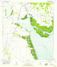
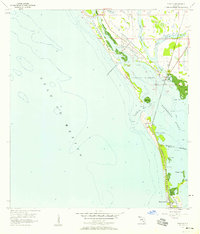
(157)- 1944 Map of Myakka River
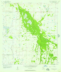
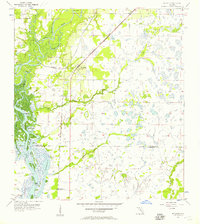
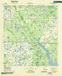 1944 Myakka River1944 Print · USGSSarasota County during the mid-forties is depicted as a landscape of river marshes and military training grounds. Genealogists and historians can trace old roads like Jackson Road and locate the wartime Bombing Area or Evans Fishing Camp.2 unique versions available
 - 1956 Map of Murdock, 1957 Print
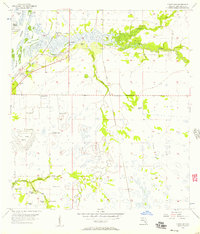
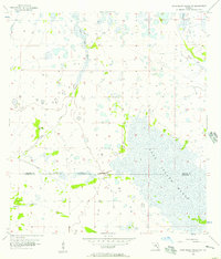
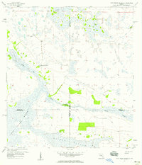
 1956 Murdock1957 Print · USGSThe Florida Gulf Coast backcountry in the mid-fifties was a landscape of expansive sloughs and pioneer rail stops. You can trace the early footprint of Murdock along the Seaboard Air Line and locate historic water sources like Little Salt Spring.3 unique versions available
 - 1956 Map of Arcadia SE, 1957 Print
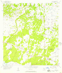
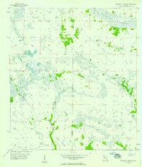
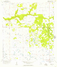
 1956 Arcadia SE1957 Print · USGSDe Soto and Charlotte counties appear as a sprawling network of wetlands and seasonal drainages in the mid-1950s. Trace the natural flow of Prairie Creek and Myrtle Slough across a landscape of isolated hammocks and early ranch roads.3 unique versions available
 - 1956 Map of Murdock SE, 1957 Print
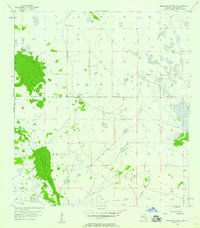
 1956 Murdock SE1957 Print · USGSFlorida's coastal interior in the mid-1950s shows a landscape of expansive wetlands at the meeting point of three counties. Genealogists and historians can trace the Seaboard Air Line Railroad Grade and locate the small settlement of Platt near the Peace River.3 unique versions available
 - 1956 Map of Telegraph Swamp, 1957 Print
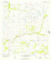
 1956 Telegraph Swamp1957 Print · USGSFlorida's Gulf Coast interior was a landscape of vast ranchlands and wetlands in the 1950s. Genealogists and historians can trace the early footprint of Babcock Ranch and identify remnants of an Old Railroad Grade through the heart of Telegraph Swamp.3 unique versions available
 - 1956 Map of Cleveland, 1957 Print
 1956 Cleveland1957 Print · USGSCharlotte County riverfront life is captured here in the mid-fifties as settlements grew along the banks of the Peace River. Researchers can trace the Atlantic Coast Line railroad, locate the Cleveland Cem, and explore the old paths of the Old Railroad Grade.4 unique versions available
 - 1956 Map of Telegraph Swamp NE, 1957 Print
 1956 Telegraph Swamp NE1957 Print · USGSThe Florida interior at the mid-century mark appears here as a vast network of wetlands and seasonal drainages. Researchers can trace the original hydrological patterns of Rainey Slough and the Branch along the Charlotte and Glades county line.2 unique versions available
 - 1956 Map of Telegraph Swamp NW, 1957 Print
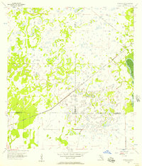
 1956 Telegraph Swamp NW1957 Print · USGSThe Florida flatwoods of Charlotte County are documented here in the mid-1950s, revealing a landscape defined by seasonal wetlands. Local history researchers can trace the path of an Old Railroad Grade and the expansive reaches of Telegraph Swamp.2 unique versions available
 - 1956 Map of Ft. Ogden, 1957 Print
 1956 Ft. Ogden1957 Print · USGSDeSoto and Charlotte counties during the mid-fifties show a landscape defined by the winding Peace River and a developing rail network. Genealogists and historians can trace family roots through the Ft Ogden Cem, Hull Cem, and early settlements like Southfort and Morgantown.4 unique versions available
 - 1956 Map of Long Island Marsh SW, 1957 Print
 1956 Long Island Marsh SW1957 Print · USGSThe DeSoto and Charlotte county line in the mid-fifties was a landscape of intricate wetlands and prairie. Genealogists and environmental historians can trace the natural drainage of Long Island Marsh and locate landmarks like Myrtle Slough and Rattlesnake Gully.3 unique versions available
 - 1956 Map of Punta Gorda SE, 1957 Print
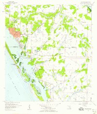
 1956 Punta Gorda SE1957 Print · USGSCoastal Charlotte County appears here in the mid-fifties, showing a landscape defined by mangrove keys and the early infrastructure of the Florida Gulf Coast. Researchers can trace the Atlantic Coast Line rail route and locate local landmarks like Cockroach Mound, John Quiet Lakes, and South Punta Gorda Heights.5 unique versions available
 - 1956 Map of Bermont, 1957 Print
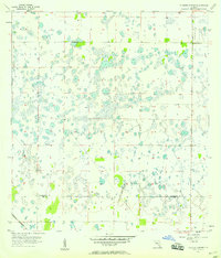
 1956 Bermont1957 Print · USGSCharlotte County was still a landscape of remote wetlands and timber tracks in the mid-1950s. You can trace the Old Railroad Grade through Telegraph Swamp and locate the small outpost of Bermont.3 unique versions available
 - 1956 Map of Englewood, 1958 Print
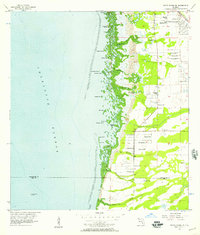
 1956 Englewood1958 Print · USGSThe Gulf Coast between Sarasota and Charlotte counties is captured here in the mid-fifties during its transition from ranching to coastal residential life. Genealogists and local historians can trace early development in Englewood and Grove City, or find landmarks like the Englewood Sch and Placida Ch.4 unique versions available
 - 1956 Map of West Palm Beach, 1964 Print
 1956 West Palm Beach1964 Print · USGSSouth Florida during the mid-fifties exhibits a fascinating balance between expanding coastal cities and the vast interior wetlands. Researchers can trace the development of inland settlements like Immokalee and Okeelanta or locate vanished landmarks like Chosen and Buckingham Cem.2 unique versions available
 - 1956 Map of Tampa, 1964 Print
 1956 Tampa1964 Print · USGSThe Florida Gulf Coast thrived in the mid-fifties, from the bustling docks of Tampa to the quiet shores of Sanibel. Genealogists and historians can trace old rail lines like the Atlantic Coast Line or find early layouts of Port Charlotte and Bokeelia.2 unique versions available
 - 1956 Map of Fort Pierce, 1965 Print
 1956 Fort Pierce1965 Print · USGSCentral and coastal Florida appear here during a period of rapid post-war growth and industrial expansion. Researchers can trace the mid-century rail-to-highway transition along the Sunshine State Parkway or locate old settlements like Ankona, Walton, and Indrio.4 unique versions available
 - 1956 Map of Charlotte Harbor, 1982 Print
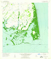
 1956 Charlotte Harbor1982 Print · USGSCoastal Florida in the mid-fifties reveals the early growth of bayside communities and the preservation of vast wetland refuges. Genealogists and historians can trace rail lines like the Seaboard Air Line and find historic waterfront locales from Boca Grande to Punta Gorda.
 - 1957 Map of Englewood NW
 1957 Englewood NW1957 Print · USGSCoastal Sarasota County is captured during the mid-fifties, when the barrier islands remained largely undeveloped. Researchers can trace the original shoreline of Lemon Bay, the winding path of Forked Creek, and the isolated County Landing Field.3 unique versions available
 - 1957 Map of West Palm Beach
 1957 West Palm Beach1957 Print · USGSSouthern Florida in the mid-fifties reveals a landscape defined by massive drainage canals and the early expansion of the Gold Coast. Genealogists and historians can trace industrial outposts like the Sugar plant and Everglades Labor Center, or locate the Jupiter Auxiliary Air Force Base.
 - 1957 Map of Long Island Marsh SE, 1958 Print
 1957 Long Island Marsh SE1958 Print · USGSThe Florida interior during the late fifties reveals a vast wetland where four counties meet amidst a landscape of sloughs and ranch land. Researchers can trace the path of the Old Railroad Grade and locate local landmarks such as Montgomery Ranch and Rainey Slough.3 unique versions available
 - 1957 Map of El Jobean, 1958 Print
 1957 El Jobean1958 Print · USGSCoastal Charlotte County in the late fifties is defined by the intersection of rail and water at the El Jobean crossing. Researchers can trace the original Seaboard Air Line tracks across the Myakka River or locate early landmarks like Cattle Dock Point and Hog Island.5 unique versions available
 - 1957 Map of Punta Gorda SW, 1958 Print
 1957 Punta Gorda SW1958 Print · USGSThe Florida Gulf Coast near the Charlotte and Lee county line is captured in the late fifties before modern coastal development. Maritime historians can trace historical landmarks and natural channels like John Quiet Mound, Cayo Pelau, and Boggess Hole.4 unique versions available
 - 1957 Map of Tuckers Corner, 1958 Print
 1957 Tuckers Corner1958 Print · USGSThe Florida interior at the edge of the wetlands is captured here in the mid-fifties, showing a landscape defined by seasonal ponds and early transit lines. Genealogists and local historians can trace the boundary between Charlotte Co and Lee Co or locate the rural settlement at Tuckers Corner near the Atlantic Coast Line railroad.3 unique versions available
 - 1957 Map of Punta Gorda, 1958 Print
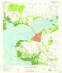 1957 Punta Gorda1958 Print · USGSCoastal Charlotte County undergoes significant mid-century development where the Peace River meets the harbor. Researchers can trace the early layout of Port Charlotte and locate family landmarks like Indian Springs Cem and Charlotte High Sch.5 unique versions available
 - 1957 Map of Placida, 1958 Print
 1957 Placida1958 Print · USGSThe Charlotte County coastline in the mid-1950s was a network of barrier islands and vital rail links. Trace the southern terminus of the Seaboard Air Line through Placida or locate the old Ferry Landing sites connecting Little Gasparilla Island and Boca Grande.4 unique versions available
Showing maps 1-25 of 157
Top cities of Charlotte County
- Port Charlotte historical maps
- Punta Gorda historical maps
- Rotonda historical maps
- Charlotte Harbor historical maps
- Cleveland historical maps
- Charlotte Park historical maps
See more
Frequently asked questions
- What are the different types of historical maps available for Charlotte County?
- What is the oldest map of Charlotte County?
- Where can I purchase historical maps of Charlotte County for my home or office?
- Where can I download high-res historical maps of Charlotte County?
- Are there historical topographic maps available for Charlotte County?
- Is there historical aerial imagery available for Charlotte County?
- Where are historical maps of Charlotte County sourced from?