1990s Maps of Marco Shores–Hammock Bay, Florida
Explore 1 historic maps of Marco Shores–Hammock Bay from the 1990s. These maps offer a rare glimpse into what life looked like during the 1990s — showing old roads, neighborhoods, homes, and landmarks that have changed or disappeared over time.
Whether you're researching your family's past, planning a metal detecting trip, or studying how Marco Shores–Hammock Bay's landscape evolved across the 1990s, these high-resolution maps are a powerful tool for exploring the history of this region.
- Focus on a specific era: All maps on this page are from the 1990s, giving you a focused view of this time period.
- See what’s changed: Compare century-old streets, trails, and buildings to today's modern landscape using overlays and satellite layers.
- Research with precision: Use these maps for genealogy, historical research, land use analysis, or educational projects.
- View, download, or print: Maps are fully viewable online in high resolution, and can be downloaded or printed for your own records.
Start exploring Marco Shores–Hammock Bay's history through authentic maps from the 1990s. This is your window into the past.
Marco Shores–Hammock Bay, FL maps
(1)- 1995 Map of Marco Island, 1999 Print
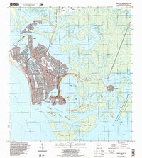 1995 Marco Island1999 Print · USGSMarco Island in the mid-nineties showcases a rapidly developing coastline defined by intricate canal systems and growing residential tracts. Researchers can trace local infrastructure from the Toll Bridge and Barfield Sch to the quiet fishing village of Goodland.
End of results
Showing maps 1-1 of 1
Top cities near Marco Shores–Hammock Bay
- Naples historical maps
- Marco Island historical maps
- Lely Resort historical maps
- Pelican Bay historical maps
- Naples Manor historical maps
- Lely historical maps
See more
Frequently asked questions
- What are the different types of historical maps available for Marco Shores–Hammock Bay?
- What is the oldest map of Marco Shores–Hammock Bay?
- Where can I purchase historical maps of Marco Shores–Hammock Bay for my home or office?
- Where can I download high-res historical maps of Marco Shores–Hammock Bay?
- Are there historical topographic maps available for Marco Shores–Hammock Bay?
- Is there historical aerial imagery available for Marco Shores–Hammock Bay?
- Where are historical maps of Marco Shores–Hammock Bay sourced from?