Old Maps of Pine Log, Florida for Hiking & Exploration
Hike through history with 15 historic maps of Pine Log. Explore old trails, ghost towns, and forgotten backroads — perfect for outdoor adventurers and local explorers.
- Rediscover forgotten places: Map out old mining camps, roads, and footpaths that no longer exist on modern maps.
- Layer with modern tools: Combine with LiDAR or satellite views to plan hikes through historical terrain.
- Made for exploration: Popular among hikers, overlanders, and local history lovers.
Use these maps to find adventure and explore the hidden past of Pine Log.
Pine Log, FL maps
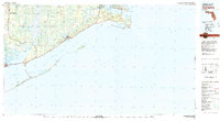
(15)- 1945 Map of Mc Intyre
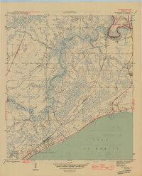 1945 Mc Intyre1945 Print · USGSThe Florida Panhandle coastline and inland forests appear here during the height of the Second World War. Researchers can trace the massive Camp Gordon Johnson complex near Lanark or locate the historic Pinelog Ferry crossing on the Crooked River.6 unique versions available
 - 1949 Map of Apalachicola
 1949 Apalachicola1949 Print · USGSThe Florida Panhandle's Forgotten Coast is captured mid-century, showcasing the intricate web of swamps, sounds, and barrier islands. Genealogists and historians can trace the Apalachicola Northern rail line and locate old landmarks like Fort Gadsden or the St Joe Fire Tower.
 - 1957 Map of Apalachicola, 1968 Print
 1957 Apalachicola1968 Print · USGSFlorida's Forgotten Coast comes alive in this mid-century portrait of timber, fishing, and military outposts. Researchers can trace the waterfronts of Apalachicola, the grounds of Fort Gadsden, and the early footprint of Mexico Beach before modern development.2 unique versions available
 - 1959 Map of Apalachicola
 1959 Apalachicola1959 Print · USGSThe Florida Panhandle's coastline is captured in the late fifties, showcasing the maritime and rail connections between Port St Joe and the oyster-rich waters of Apalachicola. Researchers can trace the legacy of Fort Gadsden or locate historic rail stops like Lanark Station and McIntyre along the coast.
 - 1960 Map of Apalachicola
 1960 Apalachicola1960 Print · USGSFlorida's Forgotten Coast was a realm of maritime industry and vast wetlands in the late fifties. Genealogists and historians can trace the rail lines of the Apalachicola Northern or locate sites like Port St Joe, the Cape St George Lighthouse, and Carrabelle.
 - 1967 Map of Apalachicola, 1975 Print
 1967 Apalachicola1975 Print · USGSCoastal Florida in the mid-twentieth century reveals a landscape of maritime navigation and expansive wetlands. Trace the Apalachicola Northern rail line to waterfront hubs like Carrabelle and the historic Cape St George Lighthouse.
 - 1978 Map of Carrabelle, 1980 Print
 1978 Carrabelle1980 Print · USGSCoastal Franklin County comes into focus during the late seventies, showing a landscape defined by maritime trade and timber. Researchers can locate historic sites like Fort Gadsden, trace the rail line past Buck Siding, or explore the reach of Tates Hell Swamp.4 unique versions available
 - 1982 Map of Mc Intyre
 1982 Mc Intyre1982 Print · USGSCoastal Franklin County in the early eighties is a landscape of river-fed wetlands and forest. Researchers can trace river access points like Big Blackjack Landing, the local footprint of Lanark Village, and the St James Fire Tower.3 unique versions available
 - 1988 Map of Apalachicola
 1988 Apalachicola1988 Print · USGSThe Florida Panhandle's Forgotten Coast comes to life in the late eighties, showing the delicate balance between wild marshlands and historic waterfront towns. Researchers can trace the shoreline from Cape San Blas to Bald Point, locating family-named landings like Hays Place and the historic grounds of Fort Gadsden.
 - 2012 Map of McIntyre, 2012 Print
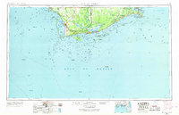
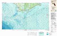
 2012 McIntyre2012 Print · USGSCovers Pine Log, including Summer Camp Beach, Lanark Village, and other nearby areas
 - 2015 Map of McIntyre, 2015 Print
 2015 McIntyre2015 Print · USGSCovers Pine Log, including Summer Camp Beach, Lanark Village, and other nearby areas
 - 2018 Map of McIntyre, 2018 Print
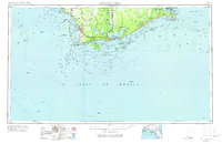
 2018 McIntyre2018 Print · USGSCovers Pine Log, including Summer Camp Beach, Lanark Village, and other nearby areas
 - 2021 Map of McIntyre, 2021 Print
 2021 McIntyre2021 Print · USGSCovers Pine Log, including Summer Camp Beach, Lanark Village, and other nearby areas
 - 2024 Map of McIntyre, 2024 Print
 2024 McIntyre2024 Print · USGSCovers Pine Log, including Summer Camp Beach, Lanark Village, and other nearby areas
 - 2025 Map of McIntyre, 2025 Print
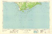
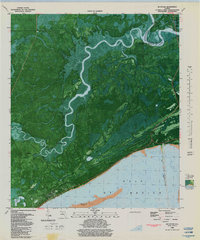
 2025 McIntyre2025 Print · USGSThe Ochlockonee and Crooked Rivers meet in this coastal stretch of the Florida Panhandle during the 2020s. Genealogists can locate family landmarks like Thompsons Cem and Cochrans Still Cem near the historic settlement of McIntyre.
End of results
Showing maps 1-15 of 15
Top cities near Pine Log
Frequently asked questions
- What are the different types of historical maps available for Pine Log?
- What is the oldest map of Pine Log?
- Where can I purchase historical maps of Pine Log for my home or office?
- Where can I download high-res historical maps of Pine Log?
- Are there historical topographic maps available for Pine Log?
- Is there historical aerial imagery available for Pine Log?
- Where are historical maps of Pine Log sourced from?