1970s Maps of Hendry County, Florida
Explore 16 historic maps of Hendry County from the 1970s. These maps offer a rare glimpse into what life looked like during the 1970s — showing old roads, neighborhoods, homes, and landmarks that have changed or disappeared over time.
Whether you're researching your family's past, planning a metal detecting trip, or studying how Hendry County's landscape evolved across the 1970s, these high-resolution maps are a powerful tool for exploring the history of this region.
- Focus on a specific era: All maps on this page are from the 1970s, giving you a focused view of this time period.
- See what’s changed: Compare century-old streets, trails, and buildings to today's modern landscape using overlays and satellite layers.
- Research with precision: Use these maps for genealogy, historical research, land use analysis, or educational projects.
- View, download, or print: Maps are fully viewable online in high resolution, and can be downloaded or printed for your own records.
Start exploring Hendry County's history through authentic maps from the 1970s. This is your window into the past.
Hendry County, FL maps
(16)- 1970 Map of Moore Haven, 1976 Print
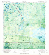
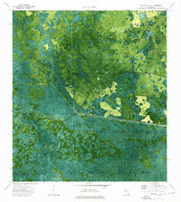
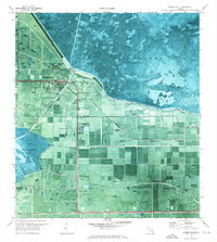 1970 Moore Haven1976 Print · USGSThe northern edge of the Everglades comes into focus in the 1970s at the intersection of water and rail. Trace the historic layout of Moore Haven, its local landmarks like St Josephs Ch, and the vast Herbert Hoover Dyke system.2 unique versions available
 - 1970 Map of Lake Harbor SW, 1976 Print
 1970 Lake Harbor SW1976 Print · USGSThe Hendry and Palm Beach borderlands in the 1970s reveal a landscape of intensive water management and wetland conversion. Researchers can trace the drainage network of the Bolles Canal past landmarks like Tonys Mound and Cowbone Hammock.
 - 1970 Map of Clewiston South, 1976 Print
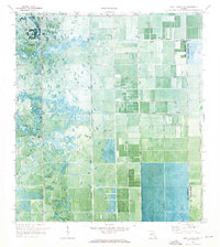
 1970 Clewiston South1976 Print · USGSAs the Everglades' sugar industry matured in the early 1970s, this survey captured the engineered landscape south of Clewiston. Trace the rail-and-canal network through Sugar Junction and identify family-named sites like Hooker Point and Keela.2 unique versions available
 - 1970 Map of La Belle 4 SE, 1976 Print
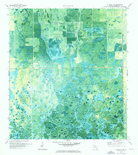
 1970 La Belle 4 SE1976 Print · USGSHendry County's inland wetlands are captured at a moment of transition in the early 1970s. Researchers can trace the intersection of nature and development along Devils Garden Slough and early transit routes like Hill Grade Road.2 unique versions available
 - 1970 Map of La Belle 4 NW, 1976 Print
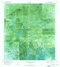
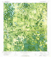
 1970 La Belle 4 NW1976 Print · USGSHendry County's landscape undergoes a transformation in the early seventies as agricultural drainage reaches into the wetlands. Genealogists and environmental historians can trace water management through Collins Slough and stations like the Pump and Radio Tower.2 unique versions available
 - 1970 Map of La Belle 4 NE, 1976 Print
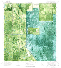
 1970 La Belle 4 NE1976 Print · USGSHendry County at the start of the 1970s shows a landscape of developing agricultural tracts and natural wetlands. Researchers can locate specific infrastructure like Airglades Airport, the southern reaches of Hog Cypress, and scattered Pump stations.2 unique versions available
 - 1971 Map of La Belle 4 SW, 1976 Print
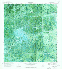 1971 La Belle 4 SW1976 Print · USGSHendry County's subtropical wetlands are captured here in the early 1970s, revealing the complex hydrology of the Florida interior. Researchers can trace the natural boundaries of Graham Marsh and locate family-named landmarks like Tom Still Hammock.2 unique versions available
 - 1971 Map of Clewiston North, 1976 Print
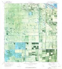
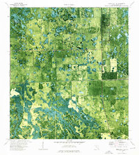
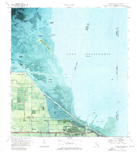 1971 Clewiston North1976 Print · USGSThe southern shores of Lake Okeechobee are shown here in the early seventies as the town of Clewiston expanded along the dike. Local researchers can trace the developed grid of Clewiston, the location of the Ridgelawn Cem, and early marsh access via an Airboat Trail.3 unique versions available
 - 1971 Map of Lake Hicpochee, 1976 Print
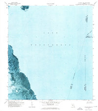
 1971 Lake Hicpochee1976 Print · USGSThe Florida Everglades transition from marsh to managed waterway in the early seventies, centered on the western shores of Lake Hicpochee. Researchers can trace the path of the Seaboard Coast Line and locate historic points like Citrus Center and an Indian Mound.
 - 1971 Map of Cochrans Pass, 1976 Print
 1971 Cochrans Pass1976 Print · USGSLake Okeechobee and its western marshlands are captured in high detail during the early 1970s. Trace the seasonal water patterns and historic navigation routes like Cochrans Pass, the Airboat Tr, and Moonshine Bay.
 - 1974 Map of Everglades 2 SW, 1976 Print
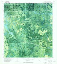
 1974 Everglades 2 SW1976 Print · USGSThe Florida Everglades meet the interior wetlands during the mid-seventies in this detailed orthophotomap of the Big Cypress Seminole Indian Reservation. Researchers can locate community landmarks like Ahfachkee Day Sch and the site of Browns Indian Trading Post (Ruins) amidst the strands.2 unique versions available
 - 1974 Map of Immokalee 1 SW, 1976 Print
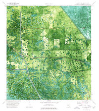
 1974 Immokalee 1 SW1976 Print · USGSSouth Florida's swampy interior is captured in the mid-seventies, showing the intersection of natural hammocks and modern infrastructure. Genealogists and historians can trace landmarks like Doctors Hammock, Dozier Hammock, and the drainage works of the Levee.2 unique versions available
 - 1974 Map of Immokalee 1 SE, 1976 Print
 1974 Immokalee 1 SE1976 Print · USGSThe Florida Everglades and Big Cypress swamp are seen here in the mid-seventies just as modern water management reached these remote stretches. Genealogists and historians can trace the Seminole Indian Reservation boundary and natural features like Cow Bone Island and Canoe Lake Strand.3 unique versions available
 - 1974 Map of Immokalee 1 NE, 1976 Print
 1974 Immokalee 1 NE1976 Print · USGSHendry County's transition from cypress wetlands to early agricultural development is captured in this mid-seventies survey. Researchers can trace the layout of Camp Everglades, the path of the Deer Fence Canal, and the isolated Landing Strip that serviced this remote landscape.2 unique versions available
 - 1974 Map of Everglades 2 NW, 1976 Print
 1974 Everglades 2 NW1976 Print · USGSThe Florida Everglades meet industrial-scale agriculture in the early 1970s at the intersection of Hendry Co and Palm Beach Co. Trace the engineered landscape along Levee 3 and locate infrastructure like Deer Fence and a remote Landing Strip.3 unique versions available
 - 1974 Map of Immokalee 1 NW, 1976 Print
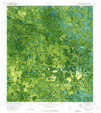
 1974 Immokalee 1 NW1976 Print · USGSHendry County's interior wetlands are captured here in the mid-1970s through detailed orthophoto imagery. Researchers can trace land patterns around Dinner Island and Crows Nest Hammock or locate the remote waters of Rocky Lake.2 unique versions available
End of results
Showing maps 1-16 of 16
Top cities of Hendry County
Frequently asked questions
- What are the different types of historical maps available for Hendry County?
- What is the oldest map of Hendry County?
- Where can I purchase historical maps of Hendry County for my home or office?
- Where can I download high-res historical maps of Hendry County?
- Are there historical topographic maps available for Hendry County?
- Is there historical aerial imagery available for Hendry County?
- Where are historical maps of Hendry County sourced from?