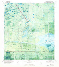
1971 Map of Lake Hicpochee
USGS Topo · Published 1976About this map
Lake Hicpochee dominates the eastern landscape of this South Florida region, where the Glades Co Hendry Co boundary line bisects a terrain of wetlands and managed waterways. In the early 1970s, the Okeechobee Waterway and Caloosahatchee Canal represent the vital hydraulic infrastructure of the Everglades, while the small settlement at Citrus Center stands as a primary point of human activity. The map reveals the character of the Florida interior through features like Beautiful Hammock and Woodyard Hammock, distinctive rises in elevation that support hardwood growth amidst the marsh. Of particular interest to local historians is the Indian Mound located south of the main highway, alongside several remote Landing Strip locations and the Seaboard Coast Line railroad cutting across the northern sections.
Find a feature on this map
12 named features on this map. Tap any name to fly to it.
Don’t see what you’re looking for? This feature index may not catch every label — zoom into the map to look around manually.
Map Details
Editions of this 1971 Lake Hicpochee Map
This is the sole edition of this map. No revisions or reprints were ever made.
Other maps of this area

1956 · West Palm Beach
USGS Topo · 1:250,000

1957 · West Palm Beach
USGS Topo · 1:250,000

1958 · West Palm Beach
USGS Topo · 1:250,000

1958 · Goodno
USGS Topo · 1:24,000

1958 · Felda NE
USGS Topo · 1:24,000
1958 · Palmdale
USGS Topo · 1:24,000

1970 · Moore Haven
USGS Topo · 1:24,000
1970 · Lakeport
USGS Topo · 1:24,000

1970 · La Belle 4 NW
USGS Topo · 1:24,000

1970 · La Belle 4 NE
USGS Topo · 1:24,000