
1970 Map of La Belle 4 NW
USGS Topo · Published 1976About this map
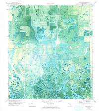
Collins Slough and the expansive Grassy Marsh define the hydrologic character of this Hendry County landscape in the early 1970s. This orthophotomap combines aerial photography with topographic data, revealing a transition between natural wetlands and early agricultural development. The geometric patterns of drainage canals and fields contrast sharply with the mottled texture of the native marshes, showing the active modification of the Florida Everglades fringe. Scattered infrastructure like a Radio Tower and various Pump stations are the primary markers of human activity in this otherwise sparsely settled area, highlighting the engineering required to manage water levels for land use.
Find a feature on this map
4 named features on this map. Tap any name to fly to it.
Don’t see what you’re looking for? This feature index may not catch every label — zoom into the map to look around manually.
Map Details
Editions of this 1970 La Belle 4 NW Map
2 editions found
Other maps of this area

1956 · West Palm Beach
USGS Topo · 1:250,000

1957 · West Palm Beach
USGS Topo · 1:250,000

1958 · West Palm Beach
USGS Topo · 1:250,000

1958 · Felda SE
USGS Topo · 1:24,000

1958 · Goodno
USGS Topo · 1:24,000

1958 · Felda NE
USGS Topo · 1:24,000

1970 · Moore Haven
USGS Topo · 1:24,000

1970 · La Belle 4 SE
USGS Topo · 1:24,000

1970 · La Belle 4 NE
USGS Topo · 1:24,000

1971 · La Belle 4 SW
USGS Topo · 1:24,000