
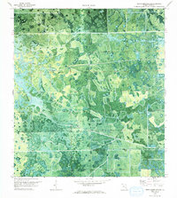
1970 Map of La Belle 4 SE
USGS Topo · Published 1976About this map
Devils Garden Slough defines the hydrologic character of this interior Florida landscape as it appeared in 1970. The orthophotomap format provides a rare visual of the transition between wet prairies, cypress stands, and the emerging geometric patterns of agricultural cleared land. Human activity is represented primarily by linear transport routes like Hill Grade Road and Dooley Road, which cut through the natural drainage patterns of the slough. This document, produced by the Geological Survey using photogrammetric methods, captures the area during a period of significant land modification, showing how rectangular drainage and field systems were being overlaid onto the ancestral wetlands of Hendry County.
Find a feature on this map
5 named features on this map. Tap any name to fly to it.
Don’t see what you’re looking for? This feature index may not catch every label — zoom into the map to look around manually.
Map Details
Editions of this 1970 La Belle 4 SE Map
2 editions found
Other maps of this area

1956 · West Palm Beach
USGS Topo · 1:250,000

1957 · West Palm Beach
USGS Topo · 1:250,000

1958 · West Palm Beach
USGS Topo · 1:250,000

1970 · Lake Harbor SW
USGS Topo · 1:24,000

1970 · Clewiston South
USGS Topo · 1:24,000

1970 · La Belle 4 NW
USGS Topo · 1:24,000

1970 · La Belle 4 NE
USGS Topo · 1:24,000

1971 · La Belle 4 SW
USGS Topo · 1:24,000

1974 · Immokalee 1 NE
USGS Topo · 1:24,000
1974 · Everglades 2 NW
USGS Topo · 1:24,000