
1974 Map of Immokalee 1 NE
USGS Topo · Published 1976About this map
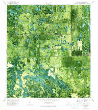
Camp Everglades sits in the northwestern corner of this 1974 orthophotomap, marking a small human footprint in the Hendry County wetlands. The landscape is a complex pattern of cypress domes and marshy depressions, punctuated by the Point of Cypress and the engineered lines of the Deer Fence Canal. This transition from natural wetland to managed land is visible in the emergence of a Landing Strip and a Radio Tower on the eastern edge of the survey. The orthophotomap format preserves the actual density of the vegetation and the scale of the agricultural fields beginning to push into the territory south of T 46 S. Private surveys and public infrastructure like the Sewage Disposal site indicate the subtle development of this interior Florida region during the mid-1970s.
Find a feature on this map
7 named features on this map. Tap any name to fly to it.
Don’t see what you’re looking for? This feature index may not catch every label — zoom into the map to look around manually.
Map Details
Editions of this 1974 Immokalee 1 NE Map
2 editions found
Other maps of this area

1956 · West Palm Beach
USGS Topo · 1:250,000

1957 · West Palm Beach
USGS Topo · 1:250,000

1958 · West Palm Beach
USGS Topo · 1:250,000

1970 · Lake Harbor SW
USGS Topo · 1:24,000

1970 · La Belle 4 SE
USGS Topo · 1:24,000

1971 · La Belle 4 SW
USGS Topo · 1:24,000

1974 · Everglades 2 SW
USGS Topo · 1:24,000

1974 · Immokalee 1 SW
USGS Topo · 1:24,000

1974 · Immokalee 1 SE
USGS Topo · 1:24,000
1974 · Everglades 2 NW
USGS Topo · 1:24,000