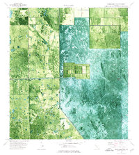
1974 Map of Everglades 2 NW
USGS Topo · Published 1976About this map
Levee 3 cuts a sharp diagonal through this 1970s orthophotomap, marking a stark divide in the South Florida landscape. This survey, compiled from 1971 aerial photography, documents the ongoing transformation of the Everglades as agricultural development began to square off against the natural wetlands. The presence of Deer Fence and a remote Landing Strip suggests the land's utility for large-scale ranching or private aviation during this era of expansion. Along the boundary between Hendry Co and Palm Beach Co, the map reveals a transition from the structured, gridded agricultural blocks in the west to the more fluid, untamed marsh patterns of the east, providing a rare visual record of water management and land use before later environmental restoration efforts changed the region's footprint.
Find a feature on this map
4 named features on this map. Tap any name to fly to it.
Don’t see what you’re looking for? This feature index may not catch every label — zoom into the map to look around manually.
Map Details
Editions of this 1974 Everglades 2 NW Map
3 editions found
Other maps of this area

1956 · West Palm Beach
USGS Topo · 1:250,000

1957 · West Palm Beach
USGS Topo · 1:250,000

1958 · West Palm Beach
USGS Topo · 1:250,000

1970 · Lake Harbor SE
USGS Topo · 1:24,000

1970 · Lake Harbor SW
USGS Topo · 1:24,000

1970 · La Belle 4 SE
USGS Topo · 1:24,000

1974 · Everglades 2 SW
USGS Topo · 1:24,000

1974 · Immokalee 1 SE
USGS Topo · 1:24,000

1974 · Immokalee 1 NE
USGS Topo · 1:24,000

1974 · Everglades 2 SE
USGS Topo · 1:24,000