
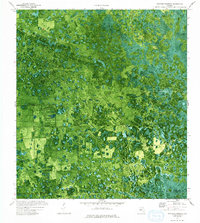
1974 Map of Immokalee 1 SW
USGS Topo · Published 1976About this map
Doctors Hammock and Dozier Hammock rise slightly above the saturated interior of the Florida Everglades, representing the varied elevations of this subtropical wilderness in the mid-1970s. This orthophotomap, produced by the U.S. Geological Survey in cooperation with the Florida Department of Transportation, utilizes aerial imagery from 1971 to reveal a landscape defined by water management and resource extraction. A complex system of human intervention is visible through a prominent Levee, a Pipeline, and a Spoil Bank, which cut across the natural hydrology of Gum Swamp. The boundary between Hendry Co and Collier Co bisects the region, where a remote Landing Strip provides one of the few points of access into this seasonally flooded terrain.
Find a feature on this map
8 named features on this map. Tap any name to fly to it.
Don’t see what you’re looking for? This feature index may not catch every label — zoom into the map to look around manually.
Map Details
Editions of this 1974 Immokalee 1 SW Map
2 editions found
Other maps of this area

1956 · West Palm Beach
USGS Topo · 1:250,000

1957 · West Palm Beach
USGS Topo · 1:250,000

1958 · West Palm Beach
USGS Topo · 1:250,000

1958 · Sunniland
USGS Topo · 1:24,000

1958 · Immokalee NE
USGS Topo · 1:24,000

1959 · Miles City
USGS Topo · 1:24,000

1974 · Immokalee 4 NW
USGS Topo · 1:24,000

1974 · Immokalee 1 SE
USGS Topo · 1:24,000

1974 · Immokalee 1 NE
USGS Topo · 1:24,000
1974 · Immokalee 4 NE
USGS Topo · 1:24,000