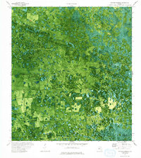
1974 Map of Doctors Hammock
USGS Topo · Published 1993About this map
Doctors Hammock and Dozier Hammock rise as distinct clusters of hardwood vegetation within the wet, low-lying landscape of the Florida Everglades. This 1974 orthophotomap, produced from 1971 aerial photography, provides a rare visual of the transition from natural wetlands to managed land. Infrastructure such as the Landing Strip, Levee, and a Pipeline reflect early attempts to control and access this interior wilderness for agriculture or industry. The northern reaches of Gum Swamp dominate the drainage pattern, while a Spoil Bank suggests dredging and earthmoving activities. The boundary between Hendry and Collier counties is clearly marked, dividing these hammocks and providing a specific point of reference for local land ownership and historical territory during a period of significant hydrological modification in southern Florida.
Find a feature on this map
9 named features on this map. Tap any name to fly to it.
Don’t see what you’re looking for? This feature index may not catch every label — zoom into the map to look around manually.
Map Details
Editions of this 1974 Doctors Hammock Map
2 editions found
Other maps of this area

1956 · West Palm Beach
USGS Topo · 1:250,000

1957 · West Palm Beach
USGS Topo · 1:250,000

1958 · West Palm Beach
USGS Topo · 1:250,000

1958 · Sunniland
USGS Topo · 1:24,000

1958 · Immokalee NE
USGS Topo · 1:24,000

1959 · Miles City
USGS Topo · 1:24,000

1974 · Immokalee 4 NW
USGS Topo · 1:24,000

1974 · Immokalee 1 SW
USGS Topo · 1:24,000

1974 · Immokalee 1 SE
USGS Topo · 1:24,000

1974 · Immokalee 1 NE
USGS Topo · 1:24,000