
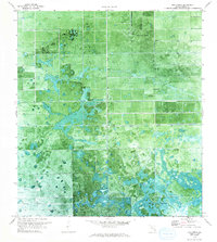
1970 Map of La Belle 4 NE
USGS Topo · Published 1976About this map
Airglades Airport serves as a prominent landmark in this segment of Hendry County, anchoring a landscape defined by Florida’s agricultural and drainage infrastructure. Based on 1970 aerial photography, the map reveals a transition between managed land and native terrain, where a systematic network of ditches and a primary Canal facilitate irrigation and water control. This reliance on mechanical water management is evidenced by several Pump and Windmill sites located throughout the township. To the south, the terrain shifts into Hog Cypress, reflecting the natural swamp ecology of the region before it gives way to the structured rows of fields and groves. Small-scale human markers like a Flagpole indicate established homesteads or administrative points within this rural expanse, providing specific points of interest for those tracing the development of South Florida's interior during the late twentieth century.
Find a feature on this map
8 named features on this map. Tap any name to fly to it.
Don’t see what you’re looking for? This feature index may not catch every label — zoom into the map to look around manually.
Map Details
Editions of this 1970 La Belle 4 NE Map
2 editions found
Other maps of this area

1956 · West Palm Beach
USGS Topo · 1:250,000

1957 · West Palm Beach
USGS Topo · 1:250,000

1958 · West Palm Beach
USGS Topo · 1:250,000

1970 · Moore Haven
USGS Topo · 1:24,000

1970 · Lake Harbor SW
USGS Topo · 1:24,000

1970 · Clewiston South
USGS Topo · 1:24,000

1970 · La Belle 4 SE
USGS Topo · 1:24,000

1970 · La Belle 4 NW
USGS Topo · 1:24,000

1971 · La Belle 4 SW
USGS Topo · 1:24,000
1971 · Clewiston North
USGS Topo · 1:24,000